Back Hattah-Kulkyne National Park CEB Hattah-Kulkyne-Nationalpark German Parc national Hattah-Kulkyne French ഹറ്റ-കുൾകൈൻ ദേശീയോദ്യാനം Malayalam Hattah-Kulkyne National Park Swedish
| Hattah-Kulkyne National Park Victoria | |
|---|---|
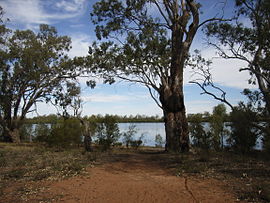
 Hattah Lake, within the national park. | |
 | |
| Nearest town or city | Mildura |
| Coordinates | 34°41′14″S 142°22′54″E / 34.68722°S 142.38167°E |
| Established | 7 June 1960[1] |
| Area | 480 km2 (185.3 sq mi)[1] |
| Managing authorities | Parks Victoria |
| Website | Hattah-Kulkyne National Park |
| Footnotes | |
| Official name | Hattah-Kulkyne Lakes |
| Designated | 15 December 1982 |
| Reference no. | 264[2] |
| See also | Protected areas of Victoria |
The Hattah-Kulkyne National Park is a national park in the Mallee district of Victoria, Australia. The 48,000-hectare (120,000-acre) national park is situated adjacent to the Murray River, approximately 417 kilometres (259 mi) northwest of Melbourne with the nearest regional centre being Mildura. The Hattah Lakes National Park was proclaimed on 7 June 1960, later being greatly expanded in 1980 and becoming the Hattah-Kulkyne National Park.[3] It is a popular destination for bushwalkers and school camping trips.[4]
- ^ a b "Mallee Parks Management Plan" (PDF). Parks Victoria (PDF). Government of Victoria. September 1996. pp. 1–3. ISBN 0-7306-6174-1. Retrieved 16 August 2014.
- ^ "Hattah-Kulkyne Lakes". Ramsar Sites Information Service. Retrieved 25 April 2018.
- ^ "Hattah Lakes" (PDF). mdba.gov.au. February 2012. Archived (PDF) from the original on 5 April 2020. Retrieved 24 May 2023.
- ^ "Hattah-Kulkyne National Park and Murray-Kulkyne Park" (PDF). Parks Victoria (PDF). Government of Victoria. June 2014. Archived from the original (PDF) on 20 August 2014. Retrieved 16 August 2014.
