Back Rechión d'a Badía de Hawke AN إقليم هاوكس باي Arabic جيهة خليج هاوك ARY Wawengkon Celuk Hawke BAN Хоукс Бей Bulgarian Hawke's Bay Catalan Hawke's Bay CEB Hawke's Bay Czech Hawke's Bay Welsh Hawke’s Bay (Region) German
Hawke's Bay
Te Matau-a-Māui (Māori) | |
|---|---|
 Hawke's Bay within New Zealand | |
| Coordinates: 39°25′S 176°49′E / 39.417°S 176.817°E | |
| Country | New Zealand |
| Island | North Island |
| Seat | Napier |
| Government | |
| • Type | Regional council |
| • Body | Hawke's Bay Regional Council |
| • Chair | Hinewai Ormsby |
| • Deputy chair | Will Foley |
| Area | |
| • Land | 14,139.15 km2 (5,459.16 sq mi) |
| Highest elevation (Kaweka J) | 1,724 m (5,656 ft) |
| Population (June 2024)[2] | |
• Total | 185,400 |
| GDP | |
| • Total | NZ$ 11.385 billion (2021) (8th) |
| • Per capita | NZ$ 61,977 (2021) |
| ISO 3166 code | NZ–HKB |
| HDI (2022) | 0.921[4] very high · 12th |
| Website | www |
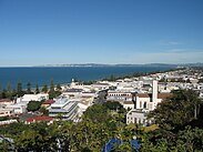
Hawke's Bay (Māori: Te Matau-a-Māui[5]) is a region on the east coast of New Zealand's North Island. The region is named for Hawke Bay, which was named in honour of Edward Hawke. The region's main centres are the cities of Napier and Hastings, while the more rural parts of the region are served by the towns of Waipukurau, Waipawa, and Wairoa.
- ^ Cite error: The named reference
Areawas invoked but never defined (see the help page). - ^ "Aotearoa Data Explorer". Statistics New Zealand. Retrieved 26 October 2024.
- ^ "Regional gross domestic product: Year ended March 2022". Statistics New Zealand. 24 March 2023. Retrieved 4 April 2023.
- ^ "Sub-national HDI – Area Database – Global Data Lab". hdi.globaldatalab.org. Retrieved 18 February 2023.
- ^ Pollock, Kerryn. 'Hawke’s Bay region – Overview'. Te Ara – the Encyclopedia of New Zealand. (accessed 9 November 2017)


