Back هزارستان Arabic Həzaracat Azerbaijani Hazaristan Breton Hazarajat Catalan Hazaradschat German Hezarıstan DIQ Hazarajat Spanish هزارستان Persian Hazaradžat Finnish Hazaradjat French
34°49′00″N 67°49′00″E / 34.8167°N 67.8167°E
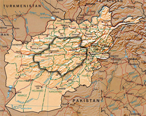
 Hazaristan region shown within Afghanistan | |
| Area | Approx: 80,000 sq mi (207,199 km2) |
|---|---|
| Population | circa 8,000,000 |
| Density | 50/km2 (130/sq mi) |
| Provinces within Hazaristan | Bamyan, Daykundi and large parts of Ghor, Ghazni, Uruzgan, Parwan, Maidan Wardak, and more.[1] |
| Ethnicity | Hazaras |
| Languages spoken | Dari and Hazaragi (eastern dialects of Persian) |
| Flag |  |
| Part of a series on |
| Hazaras |
|---|
 |
|
|
|
Hazarajat (Persian: هزارهجات, romanized: Hazārajāt), also known as Hazaristan[2][3] (Persian: هزارستان, romanized: Hazāristān) is a mostly mountainous region in the central highlands of Afghanistan, among the Kuh-e Baba mountains in the western extremities of the Hindu Kush. It is the homeland of the Hazara people who make up the majority of its population. Hazarajat denotes an ethnic and religious zone.[4]

Hazarajat is primarily made up of the provinces of Bamyan, Daykundi and large parts of Ghor, Ghazni, Uruzgan, Parwan, Maidan Wardak, and more. The most populous towns in Hazarajat are Bamyan, Yakawlang (Bamyan), Nili (Daykundi), Lal wa Sarjangal (Ghor), Sang-e-Masha (Ghazni), Gizab (Daykundi) and Behsud (Maidan Wardak). The Kabul, Arghandab, Helmand, Farah, Hari, Murghab, Balkh, and Kunduz rivers originate from Hazarajat.
- ^ "Bamyan Province". Naval Postgraduate School. 2011-11-15. Retrieved 2012-12-05.
- ^ Dames, M. Longworth (2012-04-24), "Hazāristān", Encyclopaedia of Islam, First Edition (1913-1936), Brill, retrieved 2023-09-14
- ^ DISAPPEARING PEOPLES?: INDIGENOUS GROUPS AND ETHNIC MINORITIES IN SOUTH AND CENTRAL ASIA, p.156 ("Some Hazara prefer to call the area Hazaristan, using the more modern "istan" ending.")
- ^ Khazeni, Arash. "HAZĀRA i. Historical geography of Hazārajāt". Encyclopedia Iranica. Retrieved September 15, 2011.