Back جبل هوهير ايفين ARZ Hoher Ifen CEB Hoher Ifen German Hoher Ifen French Hoher Ifen LLD Hoher Ifen Polish Hoher Ifen Swedish Високий Іфен Ukrainian 上伊芬山 Chinese
| Hoher Ifen | |
|---|---|
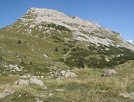
 The Hoher Ifen and the Ifen Plateau seen from the south | |
| Highest point | |
| Elevation | 2,230 m (AA) (7,320 ft) |
| Prominence | 478 m ↓ Gerach Saddle (Gerachsattel) → Großer Widderstein |
| Isolation | 7.5 km → Kleiner Widderstein |
| Coordinates | 47°21′14″N 10°05′50″E / 47.35389°N 10.09722°E |
| Geography | |
| Parent range | Northwestern Walsertal Mountains, Allgäu Alps |
| Climbing | |
| Easiest route | from the Schwarzwasser valley and from the northeast, if necessary with the aid of the chairlift |
The Hoher Ifen (also Hochifen) is a 2,230 metre[1] (according to German survey: 2,229 m[2]) high mountain in the Allgäu Alps, west of the Kleinwalsertal valley. In winter it forms the backdrop for a small ski area. It lies on the border between Germany and Austria. The summit is the highest point on the gently, tilted Ifen plateau.
Northeast of the Ifen plateau is the Gottesacker plateau, a karst landscape which has been designated a nature reserve and which has numerous caves and rare mountain plants. The most important caves are the Hölloch im Mahdtal and the Schneckenloch Cave near Schönenbach. On the eastern slopes of the massif a Stone Age dwelling site was discovered on the mountain pasture of Schneiderkürenalpe at a height of about 1,500 m.
- ^ Bundesamt für Eich- und Vermessungswesen Österreich: Austrian Map online (Österreichische Karte 1:50,000) Archived 2013-09-27 at the Wayback Machine. Accessed on 11 January 2011.
- ^ Bayerische Vermessungsverwaltung: BayernViewer 2.0 Archived 2011-10-02 at the Wayback Machine. Accessed on 11 January 2011.
