Back هولدنفيل Arabic هولدنفيل ARZ هولدنویل، اوکلاهوما AZB Holdenville Catalan Голденвилл (Оклахома) CE Holdenville CEB Holdenville DAG Holdenville (Oklahoma) German Holdenville (Oklahoma) Spanish Holdenville (Oklahoma) Basque
Holdenville, Oklahoma | |
|---|---|
 | |
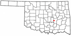
 Location of Holdenville, Oklahoma | |
| Coordinates: 35°05′01″N 96°24′06″W / 35.08361°N 96.40167°W | |
| Country | United States |
| State | Oklahoma |
| County | Hughes |
| Founded | 1895 |
| Incorporated | 1898 |
| Government | |
| • Type | Mayor-Council |
| Area | |
• Total | 5.04 sq mi (13.05 km2) |
| • Land | 5.02 sq mi (13.00 km2) |
| • Water | 0.02 sq mi (0.04 km2) |
| Elevation | 883 ft (269 m) |
| Population (2020) | |
• Total | 5,934 |
| • Density | 1,182.07/sq mi (456.44/km2) |
| Time zone | UTC-6 (Central (CST)) |
| • Summer (DST) | UTC-5 (CDT) |
| ZIP code | 74848 |
| Area codes | 405 and 572 |
| FIPS code | 40-35400[3] |
| GNIS feature ID | 2410774[2] |
| Website | cityofholdenville.net |
Holdenville is a city in and county seat of Hughes County, Oklahoma, United States.[4] The population was 5,934 at the time of the 2020 United States census.[5]
- ^ "ArcGIS REST Services Directory". United States Census Bureau. Retrieved September 20, 2022.
- ^ a b U.S. Geological Survey Geographic Names Information System: Holdenville, Oklahoma
- ^ "U.S. Census website". United States Census Bureau. Retrieved January 31, 2008.
- ^ "Find a County". National Association of Counties. Archived from the original on May 31, 2011. Retrieved June 7, 2011.
- ^ "Holdenville (city), Oklahoma". United States Census Bureau. Retrieved March 20, 2024.

