Back Honshu ACE Honsjoe Afrikaans Honshu ALS ሆንሹ Amharic هونشو Arabic هونشو ARZ Honshū AST Honşu Azerbaijani Хонсю Bashkir Honshu BAN
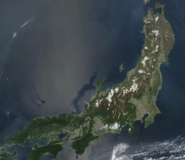
Honshu (Japanese: 本州, Hepburn: Honshū, pronounced [hoꜜɰ̃ɕɯː] ⓘ; lit. 'main island'), historically known as Akitsushima (秋津島, lit. 'dragonfly island'),[3][4][5] is the largest of the four main islands of Japan.[6][7] It lies between the Pacific Ocean (east) and the Sea of Japan (west). It is the seventh-largest island in the world, and the second-most populous after the Indonesian island of Java.[8][9][10]
Honshu had a population of 104 million as of 2017[update], constituting 81.3% of the entire population of Japan,[11] and mostly concentrated in the coastal areas and plains. Approximately 30% of the total population resides in the Greater Tokyo Area on the Kantō Plain. As the historical center of Japanese cultural and political power,[12] the island includes several past Japanese capitals, including Kyōto, Nara, and Kamakura. Much of the island's southern shore forms part of the Taiheiyō Belt, a megalopolis that spans several of the Japanese islands.[12] Honshu also contains Japan's highest mountain, Mount Fuji, and its largest lake, Lake Biwa.[13]
Most of Japan's industry is located in a belt running along Honshu's southern coast, from Tokyo to Nagoya, Kyōto, Osaka, Kobe, and Hiroshima.[12][14] The island is linked to the other three major Japanese islands by a number of bridges and tunnels. The island primarily shares two climates, with Northern Honshu having four seasons with largely varying temperatures while the south experiences long, hot summers and cool to mild winters.[15]
- ^ Farjon, Aljos; Filer, Denis (2013). An Atlas of the World's Conifers: An Analysis of their Distribution, Biogeography, Diversity and Conservation Status. BRILL. p. 268. ISBN 9789004211810.
- ^ a b "Tokyo Metropolis' Population overview – Reiwa 3 January 1" (in Japanese). Tokyo Metropolitan Government. Retrieved October 22, 2021.
- ^ "Maps ETC - Asia -> Japan". University of South Florida. Retrieved 25 June 2023.
- ^ "Ōyamatotoyoakizushima". Kokugakuin University. Retrieved 29 June 2023.
- ^ "Akitsushima". Isahaya Shrine. Retrieved 29 June 2023.
- ^ "離島とは(島の基礎知識) (what is a remote island?)". MLIT (Ministry of Land, Infrastructure, Transport and Tourism) (in Japanese). Ministry of Land, Infrastructure, Transport and Tourism. 22 August 2015. Archived from the original (website) on 2007-11-13. Retrieved 9 August 2019.
MILT classification 6,852 islands(main islands: 5 islands, remote islands: 6,847 islands)
- ^ "Honshu". Encyclopædia Britannica. Retrieved 19 February 2016.
- ^ Japan Civil Registry Database 2013
- ^ See Japan Census of 2000; the editors of List of islands by population appear to have used similar data from the relevant statistics bureaux and totalled up the various administrative districts that make up each island, and then done the same for less populous islands. An editor of this article has not repeated that work. Therefore this plausible and eminently reasonable ranking is posted as unsourced common knowledge.
- ^ "Islands By Land Area". Islands.unep.ch. Archived from the original on 2018-02-20. Retrieved 2010-08-01.
- ^ Boquet, Yves (2017). The Philippine Archipelago. Springer. p. 16. ISBN 9783319519265.
- ^ a b c Dolan, Ronald; Worden, Robert (1992). Japan: a country study. Federal Research Division, Library of Congress.
- ^ "Honshu | Facts, History, & Points of Interest". Encyclopedia Britannica. Retrieved 2021-04-14.
- ^ Kodansha Encyclopedia of Japan
- ^ Köppen, Wladimir (1884). "Die Wärmezonen der Erde, nach der Dauer der heissen, gemässigten und kalten Zeit und nach der Wirkung der Wärme auf die organische Welt betrachtet" [The thermal zones of the earth according to the duration of hot, moderate and cold periods and to the impact of heat on the organic world)] (PDF). Meteorologische Zeitschrift. 20 (3). Translated by Volken, E.; Brönnimann, S (published 2011): 351–360. Bibcode:2011MetZe..20..351K. doi:10.1127/0941-2948/2011/105. S2CID 209855204. Retrieved 2016-09-02 – via ingentaconnect.com/content/schweiz/mz/2011/00000020/00000003/art00009.

