Hooghly district

Hooghly
Hugli Jelā (Bengali)
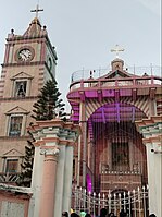
Clockwise from top-left: Durga temple of Bali Dewanganj, Hooghly Imambara, Danish cemetery at Serampore, Hooghly River, Bandel Church at Bandel
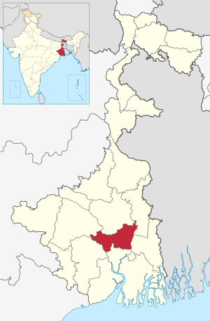
Location of Hooghly district in West Bengal
Coordinates: 22°54′N 88°23′E / 22.90°N 88.39°E / 22.90; 88.39
CountryIndia
StateWest Bengal
DivisionBurdwan
HeadquartersChinsurah
Government
 • SubdivisionsChinsurah Sadar, Chandannagar, Srirampore, Arambag
 • CD BlocksBalagarh, Chinsurah Mogra, Dhaniakhali, Pandua, Polba Dadpur, Haripal, Singur, Tarakeswar, Chanditala I, Chanditala II, Jangipara, Serampore Uttarpara, Khanakul I, Khanakul II, Goghat I, Goghat II, Pursurah
 • Lok Sabha constituenciesArambagh, Hooghly, Serampore
 • Vidhan Sabha constituenciesUttarpara, Sreerampur, Champdani, Singur, Chandannagar, Chunchura, Balagarh, Pandua, Saptagram, Chanditala, Jangipara, Haripal, Dhanekhali, Tarakeswar, Pursurah, Arambag, Goghat, Khanakul
Area
 • Total
3,149 km2 (1,216 sq mi)
Population
 (2011)
 • Total
5,519,145
 • Density1,800/km2 (4,500/sq mi)
Demographics
 • Literacy82.55 per cent
 • Sex ratio961 /
Languages
 • OfficialBengali[1][2]
 • Additional officialEnglish[1]
Time zoneUTC+05:30 (IST)
Websitehooghly.nic.in

Hooghly district (/ˈhɡl/) is one of the districts of the Indian state of West Bengal. It can alternatively be spelt Hoogli or Hugli. The district is named after the Hooghly River. The headquarters of the district are at Hooghly-Chinsurah (Chunchura). There are four subdivisions: Chinsurah Sadar, Srirampore, Chandannagore, and Arambagh.

  1. ^ a b "Fact and Figures". Wb.gov.in. Retrieved 5 July 2019.
  2. ^ "52nd Report of the Commissioner for Linguistic Minorities in India" (PDF). Nclm.nic.in. Ministry of Minority Affairs. p. 85. Archived from the original (PDF) on 25 May 2017. Retrieved 5 July 2019.

From Wikipedia, the free encyclopedia · View on Wikipedia

Developed by Nelliwinne