Back Hurdegaryp CEB Hurdegaryp German Hurdegaryp Esperanto هوردگاریپ Persian Hurdegaryp Finnish Hurdegaryp French Hurdegaryp Frisian Hardegarijp Dutch Гардегарейп Ukrainian Hardegarijp ZH-MIN-NAN
Hurdegaryp
Hardegarijp | |
|---|---|
Village | |
 Hurdegaryp, church (de Hofkerk) | |
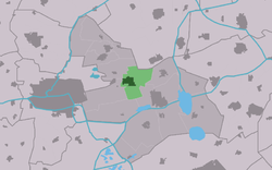
 Location of the village in Tytsjerksteradiel | |
| Coordinates: 53°12′54″N 5°56′25″E / 53.21500°N 5.94028°E | |
| Country | |
| Province | |
| Municipality | |
| Area | |
• Total | 10.58 km2 (4.08 sq mi) |
| Elevation | 0.7 m (2.3 ft) |
| Population (2021)[1] | |
• Total | 4,995 |
| • Density | 470/km2 (1,200/sq mi) |
| Postal code | 9254[1] |
| Dialing code | 0511 |
Hurdegaryp (Dutch: Hardegarijp[3]) is a village in the northern part of the Netherlands, in the municipality of Tytsjerksteradiel. Its history dates back to at least the 13th century. It had a population of around 4,788 in January 2017.[4]
In Dutch the village is called Hardegarijp, Hurdegaryp is its West Frisian and official name.
- ^ a b c "Kerncijfers wijken en buurten 2021". Central Bureau of Statistics. Retrieved 5 April 2022.
- ^ "Postcodetool for 9254AA". Actueel Hoogtebestand Nederland (in Dutch). Het Waterschapshuis. Archived from the original on 21 September 2013. Retrieved 5 April 2022.
- ^ Taalunie (2019). "Friese namen" (in Dutch). Retrieved 18 November 2019.
- ^ Overzicht inwonersaantal Tytsjerksteradiel - Tytsjerksteradiel


