Back Ille-et-Vilaine Afrikaans Département Ille-et-Vilaine ALS Il-ha-Gwilen AN إيل وفيلان (إقليم فرنسي) Arabic ايل-اى-ڤيلين ARZ Ille y Vilaine AST İl və Vilen Azerbaijani Ille-et-Vilaine BAN Іль і Вілен Byelorussian Іль і Вілен BE-X-OLD
Ille-et-Vilaine
| |
|---|---|
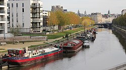
 The river Vilaine flowing through Rennes | |
 Location of Ille-et-Vilaine in France | |
| Coordinates: 48°10′N 01°40′W / 48.167°N 1.667°W | |
| Country | France |
| Region | Brittany |
| Prefecture | Rennes |
| Subprefectures | Fougères Redon Saint-Malo |
| Government | |
| • President of the Departmental Council | Jean-Luc Chenut[1] (PS) |
| Area | |
• Total | 6,775 km2 (2,616 sq mi) |
| Population (2022)[2] | |
• Total | 1,109,232 |
| • Rank | 21st |
| • Density | 160/km2 (420/sq mi) |
| Time zone | UTC+1 (CET) |
| • Summer (DST) | UTC+2 (CEST) |
| ISO 3166 code | FR-35 |
| Department number | 35 |
| Arrondissements | 4 |
| Cantons | 27 |
| Communes | 333 |
| ^1 French Land Register data, which exclude estuaries, and lakes, ponds, and glaciers larger than 1 km2 | |
Ille-et-Vilaine (French pronunciation: [il e vilɛn] ⓘ; Gallo: Ill-e-Vilaenn, Breton: Il-ha-Gwilen) is a department of France, located in the region of Brittany in the northwest of the country. It is named after its two main rivers, the Ille and the Vilaine. It had a population of 1,079,498 in 2019.[3]
- ^ "Répertoire national des élus: les conseillers départementaux". data.gouv.fr, Plateforme ouverte des données publiques françaises (in French). 4 May 2022.
- ^ "Populations de référence 2022" (in French). The National Institute of Statistics and Economic Studies. 19 December 2024.
- ^ Populations légales 2019: 35 Ille-et-Vilaine, INSEE

