Back Indus Afrikaans Indus ALS ኢንዱስ ወንዝ Amharic Río Indo AN Indus ANG نهر السند Arabic واد سند ARY نهر السند ARZ সিন্ধু নদী Assamese Ríu Indo AST
| Indus Mehran, Sênggê Zangbo, Shiquan He, Sindhu[1] | |
|---|---|
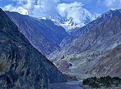
 The Indus Gorge is formed as the Indus River bends around the Nanga Parbat massif, shown towering behind, defining the western anchor of the Himalayan mountain range. | |
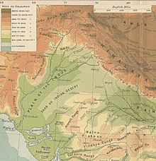
 Course and major tributaries of the Indus | |
| Native name | سندھ |
| Location | |
| Country | China, Kashmir (disputed region[2]), Pakistan |
| States or provinces | Tibet Autonomous Region, Ladakh, Gilgit-Baltistan, Khyber Pakhtunkhwa, Punjab, and Sindh |
| Cities | Leh, Kargil, Skardu, Dasu, Besham, Thakot, Swabi, Dera Ismail Khan, Mianwali, Bhakkar, Sukkur, Hyderabad, Karachi |
| Physical characteristics | |
| Source | Upper Gê'gyai |
| • location | Ngari Prefecture |
| • coordinates | 31°12′03″N 81°45′16″E / 31.20083°N 81.75444°E |
| • elevation | 5,555 m (18,225 ft) |
| 2nd source | Lake Manasarovar[3] |
| • location | Ngari Prefecture |
| • coordinates | 30°35′35″N 81°25′25″E / 30.59306°N 81.42361°E |
| • elevation | 4,600 m (15,100 ft) |
| Source confluence | |
| • location | Shiquanhe (confluence), Tibet Autonomous Region, People's Republic of China |
| • coordinates | 32°29′54″N 79°41′28″E / 32.49833°N 79.69111°E |
| • elevation | 4,255 m (13,960 ft) |
| Mouth | Arabian Sea[4] |
• location |
|
• coordinates | 23°59′42″N 67°26′06″E / 23.99500°N 67.43500°E |
• elevation | 0 m (0 ft) |
| Length | 3,180 km (1,980 mi)[5] |
| Basin size | 1,120,000 km2 (430,000 sq mi)[5] |
| Discharge | |
| • location | Indus Delta |
| • average | 5,533 m3/s (195,400 cu ft/s)[6] |
| • minimum | 1,200 m3/s (42,000 cu ft/s) |
| • maximum | 58,000 m3/s (2,000,000 cu ft/s) |
| Discharge | |
| • location | Sukkur |
| • average | (Period: 1971–2000)5,673.5 m3/s (200,360 cu ft/s)[7] |
| Discharge | |
| • location | Mithankot |
| • average | (Period: 1971–2000)5,812.3 m3/s (205,260 cu ft/s)[7] |
| Discharge | |
| • location | Tarbela Dam |
| • average | (Period: 1971–2000)2,469 m3/s (87,200 cu ft/s)[7] |
| Basin features | |
| Progression | Arabian Sea |
| River system | Indus River |
| Tributaries | |
| • left | Zanskar, Suru, Soan, Panjnad, Ghaggar |
| • right | Shyok, Hunza, Gilgit, Swat, Kunar, Kabul, Kurram, Gomal, Zhob |
 | |
The Indus (/ˈɪndəs/ IN-dəs) is a transboundary river of Asia and a trans-Himalayan river of South and Central Asia.[8] The 3,180 km (1,980 mi)[5] river rises in mountain springs northeast of Mount Kailash in Western Tibet, flows northwest through the disputed region of Kashmir,[2] bends sharply to the left after the Nanga Parbat massif, and flows south-by-southwest through Pakistan, before emptying into the Arabian Sea near the port city of Karachi.[9][10]
The river has a total drainage area of circa 1,120,000 km2 (430,000 sq mi).[5] Its estimated annual flow is around 175 km3/a (5,500 m3/s), making it one of the 50 largest rivers in the world in terms of average annual flow.[11] Its left-bank tributary in Ladakh is the Zanskar River, and its left-bank tributary in the plains is the Panjnad River which is formed by the successive confluences of the five Punjab rivers, namely the Chenab, Jhelum, Ravi, Beas, and Sutlej rivers. Its principal right-bank tributaries are the Shyok, Gilgit, Kabul, Kurram, and Gomal rivers. Beginning in a mountain spring and fed with glaciers and rivers in the Himalayan, Karakoram, and Hindu Kush ranges, the river supports the ecosystems of temperate forests, plains, and arid countryside.
The northern part of the Indus Valley, with its tributaries, forms the Punjab region of South Asia, while the lower course of the river ends in a large delta in the southern Sindh province of Pakistan. The river has historically been important to many cultures of the region. The 3rd millennium BC saw the rise of Indus Valley Civilisation, a major urban civilization of the Bronze Age. During the 2nd millennium BC, the Punjab region was mentioned in the Rigveda hymns as Sapta Sindhu and in the Avesta religious texts as Hapta Həndu (both terms meaning "seven rivers"). Early historical kingdoms that arose in the Indus Valley include Gandhāra, and the Ror dynasty of Sauvīra. The Indus River came into the knowledge of the Western world early in the classical period, when King Darius of Persia sent his Greek subject Scylax of Caryanda to explore the river, c. 515 BC.[citation needed]
- ^ Lodrick, Deryck; Ahmad, Nafis (12 November 2024). Indus River. Encyclopedia Britannica. Retrieved 25 November 2024.
Also Mehran, Sênggê Zangbo, Shiquan He, Sindhu ... The river's conventional name derives from the Tibetan and Sanskrit name Sindhu. The earliest chronicles and hymns of the Indo-European-speaking peoples of ancient India, the Rigveda, composed about 1500 bce, mention the river, which is the source of the country's name.
- ^ a b "Kashmir: region, Indian subcontinent". Encyclopædia Britannica. Archived from the original on 13 August 2019. Retrieved 16 July 2016. Quote: "Kashmir, region of the northwestern Indian subcontinent. It is bounded by the Uygur Autonomous Region of Xinjiang to the northeast and the Tibet Autonomous Region to the east (both parts of China), by the Indian states of Himachal Pradesh and Punjab to the south, by Pakistan to the west, and by Afghanistan to the northwest. The northern and western portions are administered by Pakistan and comprise three areas: Azad Kashmir, Gilgit, and Baltistan, ... The southern and southeastern portions constitute the Indian state of Jammu and Kashmir. The Indian- and Pakistani-administered portions are divided by a "line of control" agreed to in 1972, although neither country recognizes it as an international boundary. In addition, China became active in the eastern area of Kashmir in the 1950s and since 1962 has controlled the northeastern part of Ladakh (the easternmost portion of the region)."
- ^ Ahmad, Ijaz; Zhang, Fan; Tayyab, Muhammad; Anjum, Muhammad Naveed; Zaman, Muhammad; Liu, Junguo; Farid, Hafiz Umar; Saddique, Qaisar (15 November 2018). "Spatiotemporal analysis of precipitation variability in annual, seasonal and extreme values over upper Indus River basin". Atmospheric Research. 213: 346–60. Bibcode:2018AtmRe.213..346A. doi:10.1016/j.atmosres.2018.06.019. ISSN 0169-8095. S2CID 125980503.
- ^ a b Lodrick, Deryck; Ahmad, Nafis (12 November 2024). Indus River. Encyclopedia Britannica. Retrieved 25 November 2024.
Near Tatta the Indus branches into distributaries that form a delta and join the sea at various points south-southeast of Karachi. The delta covers an area of 3,000 square miles (7,800 square km) or more (and extends along the coast for about 130 miles (210 km). The uneven surface of the delta contains a network of existing and abandoned channels. The coastal strip, from about 5 to 20 miles (8 to 32 km) inland, is flooded by high tides. The Indus delta has elongated protruding distributaries and low sandy beaches.
- ^ a b c d Shrestha AB, Agrawal NK, Alfthan B, Bajracharya SR, Maréchal J, van Oort B (eds.). The Himalayan Climate and Water Atlas: Impact of Climate Change on Water Resources in Five of Asia's Major River Basins. International Centre for Integrated Mountain Development. p. 58. ISBN 978-92-9115-357-2. Archived from the original on 17 August 2024. Retrieved 21 September 2022.
- ^ Amir, Khan; Naresh, Pant; Anuj, Goswami; Ravish, Lal; Rajesh, Joshi (December 2015). "Critical Evaluation and Assessment of Average Annual Precipitation in The Indus, The Ganges and The Brahmaputra Basins, Northern India – Himalayan Cryospheric Observations and Modelling (HiCOM)".
- ^ a b c "Indus".
- ^ Richardson, Hugh E.; Wylie, Turrell V.; Falkenheim, Victor C.; Shakabpa, Tsepon W. D. (3 March 2020). "Tibet". Encyclopedia Britannica. Archived from the original on 14 August 2021. Retrieved 9 August 2021.
historic region and autonomous region of China that is often called "the roof of the world." It occupies a vast area of plateaus and mountains in Central Asia
- ^ Ahmad, Nafis; Lodrick, Deryck (6 February 2019). "Indus River". Encyclopedia Britannica. Archived from the original on 7 May 2020. Retrieved 5 February 2021.
- ^ Natural Wonders of the World. Penguin Random House/DK & Smithsonian. 2017. p. 240. ISBN 978-1-4654-9492-4. Archived from the original on 17 August 2024. Retrieved 5 February 2021.
- ^ "Indus water flow data in to reservoirs of Pakistan". Archived from the original on 6 August 2017. Retrieved 15 August 2017.