Back Inland Empire Afrikaans كاليفورنيا إينلاند إمباير Arabic اینلاند امپیر AZB Inland Empire Czech Inland Empire German Inland Empire (California) Spanish اینلند امپایر Persian Inland Empire Finnish Inland Empire (Californie) French מטרופולין ריברסייד-סן ברנרדינו-אונטריו HE
Inland Empire | |
|---|---|
 | |
 | |
| Country | United States |
| State | California
|
| Counties |
|
| Ten largest cities by population (2010 U.S. Census) |
|
| Area | |
| • Metro | 27,298 sq mi (70,669 km2) |
| Elevation | −220 – 11,499 ft (−67.1 – 3,507 m) |
| Population (2020)[2] | |
| • Density | 147.5/sq mi (56.9/km2) |
| • Urban | 1,932,666 (22nd) |
| • Urban density | 3,434.1/sq mi (1,325.9/km2) |
| • Metro | 4,599,839 (12th) |
| • Combined Statistical Area (CSA) | 18,710,563 [1] (2nd) |
| GDP | |
| • Metro | $256.859 billion (2023) |
| Time zone | UTC−08:00 (PST) |
| • Summer (DST) | UTC−07:00 (PDT) |
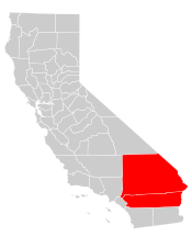
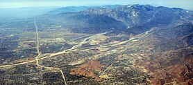
The Inland Empire (commonly abbreviated as the IE) is a metropolitan area and region inland of and adjacent to coastal Southern California, centering around the cities of San Bernardino and Riverside, and bordering Los Angeles County and Orange County to the west and San Diego County to the south. The bulk of the population is centered in the cities of northwestern Riverside County and southwestern San Bernardino County, and is sometimes considered to include the desert communities of the Coachella and Victor Valleys, respectively on the other sides of the San Gorgonio Pass and San Bernardino Mountains from the Santa Ana River watershed that forms the bulk of the Inland Empire; a much broader definition includes all of Riverside and San Bernardino counties.[4] The combined land area of the counties of the Inland Empire is larger than ten U.S. states—West Virginia, Maryland, Hawaii, Massachusetts, Vermont, New Hampshire, New Jersey, Connecticut, Delaware, and Rhode Island.
The U.S. Census Bureau–defined Riverside–San Bernardino–Ontario metropolitan area, which comprises Riverside County and San Bernardino County, California, covers more than 27,000 sq mi (70,000 km2) and had a population of about 4.6 million in 2020.[5] At the end of the 19th century, the Inland Empire was a major center of agriculture, including citrus, dairy, and winemaking. Agriculture declined through the 20th century, and since the 1970s a rapidly growing population, fed by families migrating in search of affordable housing, has led to more residential, industrial, and commercial development.
- ^ "USA: Combined Metropolitan Areas". CityPopulation.de. August 2021. Retrieved November 19, 2021.
- ^ "2020 Census, US Census Bureau". Archived from the original on August 12, 2021. Retrieved August 13, 2021.
- ^ "Total Gross Domestic Product for Riverside-San Bernardino-Ontario, CA (MSA)". fred.stlouisfed.org.
- ^ Cite error: The named reference
Rosenblattwas invoked but never defined (see the help page). - ^ "Annual Estimates of the Population of Combined Statistical Areas: April 1, 2000 to July 1, 2010". 2006 Population Estimates. U.S. Census Bureau, Population Division. April 7, 2010. Archived from the original (CSV) on September 14, 2007. Retrieved December 2, 2007.


