Back مقاطعة جاكسون (مسيسيبي) Arabic Jackson County, Mississippi BAR Джаксън (окръг, Мисисипи) Bulgarian জ্যাকশন কাউন্টি, মিসিসিপি BPY Jackson Gông (Mississippi) CDO Джексон (гуо, Миссисипи) CE Jackson County (kondado sa Tinipong Bansa, Mississippi) CEB Jackson County, Mississippi Welsh Jackson County (Mississippi) Danish Jackson County (Mississippi) German
Jackson County | |
|---|---|
 The Jackson County Courthouse in Pascagoula | |
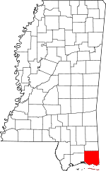
 Location within the U.S. state of Mississippi | |
 Mississippi's location within the U.S. | |
| Coordinates: 30°28′N 88°37′W / 30.46°N 88.62°W | |
| Country | |
| State | |
| Founded | 1812 |
| Named for | Andrew Jackson |
| Seat | Pascagoula |
| Largest city | Pascagoula |
| Area | |
• Total | 1,043 sq mi (2,700 km2) |
| • Land | 723 sq mi (1,870 km2) |
| • Water | 321 sq mi (830 km2) 31% |
| Population (2020) | |
• Total | 143,252 |
• Estimate (2023) | 146,389 |
| • Density | 140/sq mi (53/km2) |
| Time zone | UTC−6 (Central) |
| • Summer (DST) | UTC−5 (CDT) |
| Congressional district | 4th |
| Website | www |
Jackson County is a county located in the U.S. state of Mississippi. As of the 2020 census, the population was 143,252,[1] making it the fifth-most populous county in Mississippi. Its county seat is Pascagoula.[2] The county was named for Andrew Jackson, general in the United States Army and afterward President of the United States.[3] Jackson County is included in the Pascagoula, MS Metropolitan Statistical Area. It is located at the southeastern tip of the state. The county has sandy soil and is in the Piney Woods area. It borders the state of Alabama on its east side. The county was severely damaged by both Hurricane Camille in August 1969 and Hurricane Katrina on August 29, 2005, which caused catastrophic effects.
- ^ "Census - Geography Profile: Jackson County, Mississippi". United States Census Bureau. Retrieved January 9, 2023.
- ^ "Find a County". National Association of Counties. Archived from the original on May 31, 2011. Retrieved June 7, 2011.
- ^ Gannett, Henry (1905). The Origin of Certain Place Names in the United States. Govt. Print. Off. p. 167.
