Back জলপাইগুড়ি বিভাগ Bengali/Bangla Jalpaiguri (Division) German بخش جالپایگوری Persian જલપાઈગુડી વિભાગ Gujarati जलपाईगुड़ी मंडल Hindi Divisione di Jalpaiguri Italian ᱡᱚᱞᱯᱟᱭᱜᱩᱲᱤ ᱠᱷᱚᱸᱰ SAT Jalpaiguri division SIMPLE ஜல்பைகுரி கோட்டம் Tamil جلپائیگوری ڈویژن Urdu
This article needs additional citations for verification. (July 2013) |
Jalpaiguri | |
|---|---|
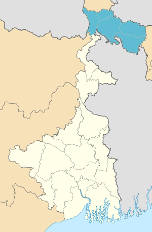
 Location of Jalpaiguri division in West Bengal | |
| Coordinates: 26°41′N 88°45′E / 26.683°N 88.750°E | |
| Country | India |
| State | West Bengal |
| Headquarters | Jalpaiguri |
| Government | |
| • Districts | Alipurduar, Cooch Behar, Darjeeling, Jalpaiguri, Kalimpong |
| Area | |
• Total | 12,713 km2 (4,909 sq mi) |
| Population (2011) | |
• Total | 8,538,755 |
| • Density | 670/km2 (1,700/sq mi) |
| Languages | |
| • Official | Bengali[1][2] |
| • Additional official | English[1] |
| Time zone | UTC+05:30 (IST) |
| Website | wb |
Jalpaiguri Division is one of the 5 divisions in the Indian state of West Bengal. It is the northernmost division of West Bengal. It is surrounded by Nepal on the western side, Bihar on South-Western side, Bhutan on the Northern side and Bangladesh on the southern side.[3]
- ^ a b "Fact and Figures". Wb.gov.in. Retrieved 5 July 2019.
- ^ "52nd Report of the Commissioner for Linguistic Minorities in India" (PDF). Nclm.nic.in. Ministry of Minority Affairs. p. 85. Archived from the original (PDF) on 25 May 2017. Retrieved 5 July 2019.
- ^ "Divisional Commissioners/ West Bengal". Office of the Resident Commissioner- Govt. of WB. 4 June 2019.