Back Jeffreysbaai Afrikaans Jeffrey's Bay CEB Jeffreys Bay German Bahía de Jeffreys Spanish Jeffreys Bay Estonian Jeffreys Bay Finnish Jeffreys Bay French Ջեֆֆրիս Բեյ Armenian Jeffreys Bay Italian Jeffreysbaai NDS-NL
Jeffreys Bay
Jeffreysbaai | |
|---|---|
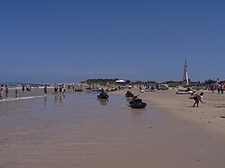
 Jeffreys Bay Beach | |
| Coordinates: 34°2′S 24°55′E / 34.033°S 24.917°E | |
| Country | South Africa |
| Province | Eastern Cape |
| District | Sarah Baartman |
| Municipality | Kouga |
| Area | |
• Total | 20.79 km2 (8.03 sq mi) |
| Population (2011)[1] | |
• Total | 27,107 |
| • Density | 1,300/km2 (3,400/sq mi) |
| Racial makeup (2011) | |
| • Black African | 37.5% |
| • Coloured | 22.7% |
| • Indian/Asian | 0.2% |
| • White | 38.9% |
| • Other | 0.7% |
| First languages (2011) | |
| • Afrikaans | 54.4% |
| • Xhosa | 28.8% |
| • English | 11.8% |
| • Other | 5.0% |
| Time zone | UTC+2 (SAST) |
| Postal code (street) | 6330 |
| PO box | 6330 |
| Area code | +27 (0)42 |
Jeffreys Bay (Afrikaans: Jeffreysbaai, nicknamed J-bay) is a town of 27,107 inhabitants as of the 2011 census in the Eastern Cape province of South Africa. It is the seat of the Kouga municipality and is famous amongst surfers as a surf capital due to the right-hand point break at Supertubes Beach. The town is situated just off the N2 Highway, about 75 kilometres southwest of Port Elizabeth.
- ^ a b c d "Main Place Jeffreys Bay". Census 2011.


