Back مرج ابن عامر Arabic مرج ابن عامر ARZ Vall de Jizreel Catalan Jizre'elské údolí Czech Jesreelebene German Valo de Jizre'el Esperanto Valle de Jezreel Spanish Jezreelgo harana Basque مرج ابن عامر Persian Jisreelin tasanko Finnish
| Jezreel Valley | |
|---|---|
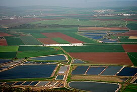
 Agriculture in the Jezreel Valley | |
 | |
| Geography | |
| Location | |
| Coordinates | 32°35′47″N 35°14′31″E / 32.59639°N 35.24194°E |
The Jezreel Valley (from the Hebrew: עמק יזרעאל, romanized: ʿĒmeq Yīzrəʿēl), or Marj Ibn Amir (Arabic: مرج ابن عامر, romanized: Marj Ibn ʿĀmir), also known as the Valley of Megiddo,[dubious – discuss][1][2][better source needed][3] is a large fertile plain and inland valley in the Northern District of Israel. It is bordered to the north by the highlands of the Lower Galilee region, to the south by the Samarian highlands, to the west and northwest by the Mount Carmel range, and to the east by the Jordan Valley, with Mount Gilboa marking its southern extent. The largest settlement in the valley is the city of Afula, which lies near its center.
- ^ Frank Jacobs (23 July 2010). "187 - A Map of the Apocalypse". Big Think. Retrieved 27 March 2019.
- ^ "Getting Blown Away at Armageddon". Leaderworks. 28 October 2018. Archived from the original on 23 October 2018. Retrieved 27 March 2019.
- ^ Immanuel Benzinger, Esdraelon 2. In: Paulys Realencyclopädie der classischen Altertumswissenschaft (RE). Band VI, 1, Stuttgart 1907, cc625-626.