Back منطقة جهرجودا Arabic جهرجودا ARZ झारसुगुड़ा जिला Bihari ঝারসুগুড়া জেলা Bengali/Bangla Jharsuguda (distrito sa Indiya) CEB Jharsuguda (Distrikt) German Distrito de Jharsuguda Spanish Jharsuguda barrutia Basque بخش جارسوگودا Persian Jharsugudan piirikunta Finnish
This article needs additional citations for verification. (September 2011) |
Jharsuguda district | |
|---|---|
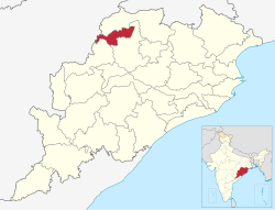
 Location in Odisha | |
| Coordinates: 21°51′00″N 84°00′58″E / 21.85°N 84.016°E | |
| Country | |
| State | |
| Headquarters | Jharsuguda |
| Government | |
| • Collector | Aboli Sunil Naravane, IAS |
| • Divisional Forest Officer Cum Wildlife Warden | Sushant Kumar, IFS |
| • Member of Lok Sabha | Suresh Pujari |
| Area | |
• Total | 2,081 km2 (803 sq mi) |
| Population (2011)[1] | |
• Total | 579,505 |
| • Density | 278/km2 (720/sq mi) |
| Languages | |
| • Official | Odia, English |
| • Local | Sambalpuri, Kurukh, Munda, Kharia |
| Time zone | UTC+5:30 (IST) |
| PIN | 768 201,2,3 |
| Vehicle registration | OD-23 |
| Nearest city | Sambalpur, Rourkela, Sundargarh |
| Sex ratio | 1.057 ♂/♀ |
| Literacy | 71.4% |
| Lok Sabha constituency | Bargarh |
| Vidhan Sabha constituency | 2, 1.Brajarajnagar, 2.Jharsuguda |
| Climate | Aw (Köppen) |
| Precipitation | 1,527 mm (60.1 in) |
| Avg. summer temperature | 46.7 °C (116.1 °F) |
| Website | www |
| This article is part of a series on |
| Odisha |
|---|
 |
| Governance |
| Topics |
|
Districts Divisions |
| GI Products |
|
|
Jharsuguda is a district in Odisha, India with Jharsuguda town as its headquarters. This region is rich in coal and other mineral reserves. Of late, many small and medium scale iron and steel units have been set up in the vicinity of Jharsuguda town, giving impetus to the industrial growth of the district.


