Back مقاطعة جونسون (إنديانا) Arabic جونسون كاونتى، انديانا ARZ جانسون بؤلگهسی، ایندیانا AZB Johnson County, Indiana BAR Джонсън (окръг, Индиана) Bulgarian জোন্সোন কাউন্টি, ইন্ডিয়ানা BPY Johnson Gông (Indiana) CDO Джонсон (гуо, Индиана) CE Johnson County (kondado sa Tinipong Bansa, Indiana) CEB Johnson County, Indiana Welsh
Johnson County | |
|---|---|
 Johnson County courthouse in Franklin, Indiana | |
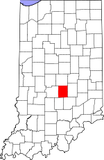
 Location within the U.S. state of Indiana | |
 Indiana's location within the U.S. | |
| Coordinates: 39°29′N 86°06′W / 39.49°N 86.1°W | |
| Country | |
| State | |
| Founded | 1823 |
| Seat | Franklin |
| Largest city | Greenwood |
| Area | |
• Total | 321.79 sq mi (833.4 km2) |
| • Land | 320.43 sq mi (829.9 km2) |
| • Water | 1.36 sq mi (3.5 km2) 0.42% |
| Population (2020) | |
• Total | 161,765 |
• Estimate (2023) | 167,819 |
| • Density | 500/sq mi (190/km2) |
| Time zone | UTC−5 (Eastern) |
| • Summer (DST) | UTC−4 (EDT) |
| Congressional district | 6th |
| Website | www |
| Indiana county number 41 | |
Johnson County is a county located in the U.S. state of Indiana. As of 2020, the population was 161,765.[1] The county seat is Franklin.[2] Johnson County is included in the Indianapolis-Carmel-Anderson, IN Metropolitan Statistical Area.
- ^ "Johnson County QuickFacts". United States Census Bureau. Archived from the original on June 7, 2011. Retrieved September 25, 2011.
- ^ "Find a County". National Association of Counties. Archived from the original on May 9, 2015. Retrieved June 7, 2011.