Back Johnston-atol Afrikaans جزيرة جونستون المرجانية Arabic Conston rifi Azerbaijani Johnston-Atoll BAR Джонстан (атол) Byelorussian Джонстан (атол) BE-X-OLD Атол Джонстън Bulgarian Atol Johnston BS Atol Johnston Catalan Джонстон (атолл) CE
This article's use of external links may not follow Wikipedia's policies or guidelines. (November 2024) |
Johnston Atoll | |
|---|---|
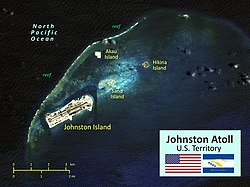
 Annotated satellite image of Johnston Atoll | |
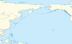
| Coordinates: 16°44′13″N 169°31′26″W / 16.73694°N 169.52389°W | |
| Country | United States |
| Status | Unorganized, unincorporated territory |
| Claimed by U.S. | March 19, 1858 |
| Named for | Captain Charles James Johnston, HMS Cornwallis |
| Government | |
| • Type | Administered as a National Wildlife Refuge |
| • Body | United States Fish and Wildlife Service |
| • Superintendent | Laura Beauregard, Pacific Islands Heritage Marine National Monument |
| Area | |
• Total | 1.03 sq mi (2.67 km2) |
| • EEZ | 157,389 sq mi (407,635 km2) |
| Highest elevation (Sand Island) | 30 ft (10 m) |
| Lowest elevation (Pacific Ocean) | 0 ft (0 m) |
| Population (2008) | |
• Total | 0 |
| Time zone | UTC−10 (Hawaii–Aleutian Time Zone) |
| Geocode | 127 |
| ISO 3166 code | UM |
| Website | www.fws.gov/refuge/Johnston_Atoll/ |
Johnston Atoll is an unincorporated territory of the United States, under the jurisdiction of the United States Air Force (USAF). The island is closed to public entry, and limited access for management needs is only granted by a letter of authorization from the USAF. A special use permit is also required from the United States Fish and Wildlife Service (USFWS) to access the island by boat or enter the waters surrounding the island, which are designated as a National Wildlife Refuge and part of the Pacific Islands Heritage Marine National Monument. The Johnston Atoll National Wildlife Refuge extends from the shore out to 12 nautical miles, continuing as part of the National Wildlife Refuge System out to 200 nautical miles. The Pacific Remote Islands Marine National Monument extends from the shore out to 200 nautical miles.
The isolated atoll has been under the control of the U.S. military since 1934.[1] During that time, it was variously used as a naval refueling depot,[2] an airbase,[3] a testing site for nuclear[4] and biological weapons,[5] a secret missile base,[6] and a site for the storage and disposal of chemical weapons[7] and Agent Orange.[8] Those activities left the area environmentally contaminated. The USAF completed remediating the contamination in 2004 and performs only periodic monitoring today.[9]
The island is home to thriving communities of nesting seabirds and has significant marine biodiversity. USAF and USFWS teams conduct environmental monitoring and maintenance to protect the native wildlife.[10]
- ^ Cite error: The named reference
U.S. Army Chemical Materials Activitywas invoked but never defined (see the help page). - ^ Cite error: The named reference
Polmar2004was invoked but never defined (see the help page). - ^ Cite error: The named reference
Baseswas invoked but never defined (see the help page). - ^ "Operation HARDTACK I: Fact Sheet" (PDF). Defense Threat Reduction Agency. September 2021. Archived (PDF) from the original on August 7, 2023. Retrieved October 18, 2023.
- ^ Cite error: The named reference
rpbiowas invoked but never defined (see the help page). - ^ Cite error: The named reference
AFmuseumwas invoked but never defined (see the help page). - ^ Cite error: The named reference
Birdswas invoked but never defined (see the help page). - ^ EarthTech (April 2005). "Appendix B" (PDF). Phase II Environmental Baseline Survey, Johnston Atoll (Report). p. B19-B20. Archived from the original (PDF) on April 21, 2013. Retrieved August 19, 2012.
- ^ Cite error: The named reference
Fish And Wildlife Servicewas invoked but never defined (see the help page). - ^ "One Remote Island's Battle Against Acid-Spewing Ants". Audubon. June 26, 2015. Archived from the original on March 4, 2021. Retrieved March 27, 2021.
