Back كاليمبونج Arabic كاليمبونج ARZ কালিম্পং Bengali/Bangla কালিম্পং BPY Kalimpong Catalan Kālimpang CEB Kalimpong Welsh Kalimpong German Kalimpong Spanish کالیمپونگ Persian
Kalimpong | |
|---|---|
Town | |
| Kalimpong Municipality | |
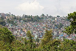
 View of Kalimpong town | |
| Coordinates: 27°04′N 88°28′E / 27.06°N 88.47°E | |
| Country | |
| State | West Bengal |
| District | Kalimpong |
| Named for | Kaley Bung |
| Government | |
| • Type | Municipality |
| • Body | Kalimpong Municipality |
| • Chairman | Rabi Pradhan |
| Area | |
• Total | 9.168 km2 (3.540 sq mi) |
| Elevation | 1,247 m (4,091 ft) |
| Population (2011)[1] | |
• Total | 49,403 |
| • Density | 5,400/km2 (14,000/sq mi) |
| Languages | |
| • Official | Nepali and Bengali[2][3] |
| • Additional official | English[2] |
| Time zone | UTC+5:30 (IST) |
| PIN | 734 301/734 316 |
| Telephone code | 03552 |
| Vehicle registration | WB-78, 79 |
| Lok Sabha constituency | Darjeeling |
| Vidhan Sabha constituency | Kalimpong |
| Website | kalimpong |
Kalimpong is a town and the headquarters of an eponymous district in the Indian state of West Bengal. It is located at an average elevation of 1,250 metres (4,101 ft).[4] The town is the headquarters of the Kalimpong district.[5] The region comes under Gorkhaland Territorial Administration which is an autonomous governing body within the state of West Bengal. The Indian Army's 27 Mountain Division is located on the outskirts of the city.[6]
Kalimpong is known for its educational institutions, many of which were established during the British colonial period.[7] It used to be a gateway in the trade between Tibet and India before China's annexation of Tibet and the Sino-Indian War. Kalimpong and neighbouring Darjeeling were major centres calling for a separate Gorkhaland state in the 1980s, and more recently in 2010.
The municipality sits on a ridge overlooking the Teesta River and is a tourist destination owing to its temperate climate, natural environment and proximity to popular tourist locations in the region. Horticulture is important to Kalimpong: It has a flower market notable for its wide array of orchids; nurseries, which export Himalayan grown flower bulbs, tubers and rhizomes, contribute to the economy of Kalimpong.[4] The Tibetan Buddhist monastery Zang Dhok Palri Phodang holds a number of rare Tibetan Buddhist scriptures.[8]
The Kalimpong Science Centre, established under the Darjeeling Gorkha Hill Council in 2008 is a recent addition to its many tourist attractions. The Science Centre, which provides for scientific awareness among the students of the town and the locals sits atop the Deolo Hill.
- ^ a b "Kalimpong Municipality". kalimpongdistrict.in. Retrieved 26 November 2020.
- ^ a b Cite error: The named reference
wblangoffwas invoked but never defined (see the help page). - ^ Cite error: The named reference
langreportwas invoked but never defined (see the help page). - ^ a b "General Information". Tourism Department. Darjeeling Gorkha Hill Council. Archived from the original on 20 November 2008. Retrieved 8 December 2008.
- ^ "Carved out of Darjeeling, Kalimpong a district today". Times of India. 14 February 2017. Retrieved 14 February 2017.
- ^ "India moves over 6,000 troops to border with China". The Hindu. Chennai, India. 13 December 2007. Archived from the original on 3 October 2008. Retrieved 8 December 2008.
- ^ "Education and prospects for employment" (PDF). Government of Sikkim. p. 33. Archived from the original (PDF) on 27 March 2009. Retrieved 21 December 2008.
- ^ "Special: Kalimpong, West Bengal". Rediff. Retrieved 8 December 2008.

