Back Propinsi Kamphaeng Phet ACE كامفاينغ فيت (محافظة) Arabic Propinsi Kamphaeng Phet BAN Кампаенг Пет Bulgarian Parupinsi Kamphaeng Phet BJN চাংৱাত কামফায়েং ফেত BPY Kamphaeng Phet Hū CDO Changwat Kamphaeng Phet (lalawigan sa Thayland) CEB پارێزگای کامفاینگ فێت CKB Kamphaeng Phet (Provinz) German
Kamphaeng Phet
กำแพงเพชร | |
|---|---|
| Kamphaeng Phet Province จังหวัดกำแพงเพชร | |
From left to right, top to bottom: Kamphaeng Phet Historical Park, Wat Chang Rob, Khlong Lan Waterfall, Wat Phra Bommathat, Wat Thung Sanun Rattanaram, Mae Wong National Park | |
| Nickname(s): Chakungrao (Thai: ชากังราว) Mueang Kluai Khai (city of lady finger bananas) | |
| Motto(s): กรุพระเครื่อง เมืองคนแกร่ง พระแสงฯ ล้ำค่า ศิลาแลงใหญ่ กล้วยไข่หวาน น้ำมันลานกระบือ เลื่องลือมรดกโลก ("Buddha amulets repository. City of the strong. Precious Phra Saeng swords. Large laterite slabs, Sweet lady finger bananas. Lan Krabue oil. Renowned world heritage.") | |
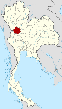
 Location of Kamphaeng Phet in Thailand | |
| Coordinates: 16°33′29″N 99°30′40″E / 16.55806°N 99.51111°E | |
| Country | |
| Established | 1916 |
| Capital | Kamphaeng Phet |
| Subdivisions | 11 districts |
| Government | |
| • Governor | Chathip Ruchanaseri (since 2022) |
| • PAO President | Sunthorn Rattanakorn (since 2012) |
| Area | |
• Total | 8,512 km2 (3,287 sq mi) |
| • Rank | 23rd |
| Population (2024)[2] | |
• Total | |
| • Rank | 38th |
| • Density | 82/km2 (210/sq mi) |
| • Rank | 58th |
| Human Achievement Index | |
| • HAI (2022) | 0.6283 "somewhat low" Ranked 58th |
| GDP | |
| • Total | baht 110 billion (US$3.8 billion) (2019) |
| Time zone | UTC+07:00 (ICT) |
| ISO 3166 code | TH-62 |
| Website | kamphaengphet |
Kamphaeng Phet (Thai: กำแพงเพชร, pronounced [kām.pʰɛ̄ːŋ pʰét]) is a province in upper central Thailand. It borders the provinces of Sukhothai to the north; Phitsanulok to the northeast; Phichit to the east; Nakhon Sawan to the south; and Tak to the west and northwest, covering over 8,512 square kilometres (3,287 sq mi) and is the fourth-largest provinces in central Thailand. Kamphaeng Phet has the Ping River flow through is main river of the province, making river flats make up much of the east of the province, while the west is mountainous which is part of Dawna Range and it covered with plentifully forest. Kamphaeng Phet known its natural environment and has a long history. National and historical parks in the province include Kamphaeng Phet Historical Park, Khlong Lan National Park, and Mae Wong National Park.
- ^ "Table 2 Forest area Separate province year 2019". Royal Forest Department. Retrieved 6 April 2021.
- ^ "Official statistics registration systems". Department of Provincial Administration (DOPA). Retrieved 10 February 2025, year 2024 >provincial level >Excel File >no.62
{{cite web}}: CS1 maint: postscript (link) - ^ "ข้อมูลสถิติดัชนีความก้าวหน้าของคน ปี 2565 (PDF)" [Human Achievement Index Databook year 2022 (PDF)]. Office of the National Economic and Social Development Council (NESDC) (in Thai). Retrieved 12 March 2024, page 18
{{cite web}}: CS1 maint: postscript (link) - ^ "Gross Regional and Provincial Product, 2019 Edition". <>. Office of the National Economic and Social Development Council (NESDC). July 2019. ISSN 1686-0799. Retrieved 22 January 2020.


