Back Кампіноская пушча Byelorussian Кампіноская пушча BE-X-OLD Bosc de Kampinos Catalan Puszcza Kampinoska CEB Puszcza Kampinoska Welsh Bosque de Kampinos Spanish جنگل کامپینوسکا Persian Forêt de Kampinos French Foresta di Kampinos Italian კამპინოს ტყე Georgian
This article needs additional citations for verification. (December 2023) |
| Kampinos Forest Polish: Puszcza Kampinoska | |
|---|---|
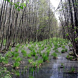
 Swamp in Kampinos Forest | |
| Map | |
| Geography | |
| Location | Masovian Voivodeship, Poland |
| Coordinates | 52°19′25″N 20°35′54″E / 52.32361°N 20.59833°E |
| Administration | |
| Events | Palmiry massacre |
Kampinos Forest (Polish: Puszcza Kampinoska) is a large forest complex located in Masovian Voivodeship, west of Warsaw in Poland.
It covers a part of the ancient valley of the Vistula basin, between the Vistula and the Bzura rivers. The forest began to form 14-11,000 years ago, at the very end of the Last Glacial Period.[1]
Once a forest covering 670 km2 of central Poland, it currently covers roughly 240 km2. In its present day form, most of the woodland is no longer old-growth forest but rather the remainders of a once-managed forest which is now left to grow on its own, with little human intervention.[2]
- ^ Jastrzębowski, Szymon; Związek, Tomasz; Marek, Jacek, eds. (2023). Puszcza Kampinoska: opowieści o wydmach, mokradłach i sosnach: przewodnik po krajobrazach przyrodniczo-kulturowych (Wydanie I ed.). Kielce: Paśny Buriat. pp. 36–42. ISBN 978-83-968741-3-9.
- ^ Jastrzębowski, Szymon; Związek, Tomasz; Marek, Jacek, eds. (2023). Puszcza Kampinoska: opowieści o wydmach, mokradłach i sosnach: przewodnik po krajobrazach przyrodniczo-kulturowych (Wydanie I ed.). Kielce: Paśny Buriat. p. 47. ISBN 978-83-968741-3-9.
