Back قرة قول (قرغيزستان) Arabic كاراكول ARZ Karakol Azerbaijani Каракол Byelorussian Каракол (град) Bulgarian Karàkol (Kirguizstan) Catalan Каракол CE Karakol (kapital sa lalawigan) CEB قاراقۆل CKB Karakol (město) Czech
This article needs additional citations for verification. (December 2009) |
Karakol
Каракол | |
|---|---|
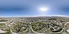
From the top to bottom-right, Panoramic view of Karakol, Tagay-Biy Statue, Holy Trinity Church, Dungan Mosque, Apartment Buildings | |
| Coordinates: 42°29′25″N 78°23′30″E / 42.49028°N 78.39167°E | |
| Country | |
| Region | Issyk-Kul Region |
| Area | |
• Total | 44 km2 (17 sq mi) |
| Elevation | 1,745 m (5,724 ft) |
| Population (2021)[1] | |
• Total | 84,351 |
| • Density | 1,900/km2 (5,000/sq mi) |
| Time zone | UTC+6 (KGZ) |
| Website | http://www.karakol.com.kg/ |
Karakol (/ˌkærəˈkoʊl/; Kyrgyz: Каракол, IPA: [qɑrɑˈqɔɫ]), formerly Przhevalsk (Russian: Пржевальск, IPA: [pr̩ʐɨˈvalʲsk]), is the fourth-largest city in Kyrgyzstan, near the eastern tip of Lake Issyk-Kul, about 150 kilometres (93 mi) from the Kyrgyzstan–China border and 380 kilometres (240 mi) from the capital Bishkek. It is the administrative capital of Issyk-Kul Region. Its area is 44 square kilometres (17 sq mi),[2] and its resident population was 84,351 in 2021 (both including Pristan'-Przheval'sk).[1] To the north, on highway A363, is Tüp, and to the southwest Jeti-Ögüz resort.
- ^ a b "Population of regions, districts, towns, urban-type settlements, rural communities and villages of Kyrgyz Republic" (XLS) (in Russian). National Statistics Committee of the Kyrgyz Republic. 2021. Archived from the original on 10 November 2021.
- ^ "2009 population and housing census of the Kyrgyz Republic: Issyk-Kul Region" (PDF) (in Russian). National Statistics Committee of the Kyrgyz Republic. 2010. pp. 11, 16, 50.


