Back كاراشوك Arabic Карашьок Bulgarian কারাসজোহকা কারাসজোক BPY Kárášjohka Catalan Karasjok (munisipyo sa Noruwega) CEB Karasjok (kommune) Danish Karasjok German Karasjok Esperanto Karasjok Spanish Kárášjohka vald Estonian
Karasjok Municipality
Karasjok kommune Kárášjoga gielda | |
|---|---|
 June 2007 view of Karasjok | |
 Finnmark within Norway | |
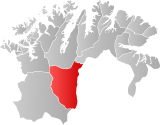
 Karasjok within Finnmark | |
| Coordinates: 69°28′55″N 25°06′18″E / 69.48194°N 25.10500°E | |
| Country | Norway |
| County | Finnmark |
| Established | 1 Jan 1866 |
| • Preceded by | Kistrand Municipality |
| Administrative centre | Karasjok |
| Government | |
| • Mayor (2015) | Svein Atle Somby (Ap) |
| Area | |
• Total | 5,452.94 km2 (2,105.39 sq mi) |
| • Land | 5,210.70 km2 (2,011.86 sq mi) |
| • Water | 242.24 km2 (93.53 sq mi) 4.4% |
| • Rank | #2 in Norway |
| Highest elevation | 1,024 m (3,360 ft) |
| Population (2024) | |
• Total | 2,565 |
| • Rank | #250 in Norway |
| • Density | 0.5/km2 (1/sq mi) |
| • Change (10 years) | |
| Demonym | Karasjoking[2] |
| Official languages | |
| • Norwegian form | Bokmål |
| • Sámi form | Northern Sami |
| Time zone | UTC+01:00 (CET) |
| • Summer (DST) | UTC+02:00 (CEST) |
| ISO 3166 code | NO-5610[4] |
| Website | Official website |
ⓘ (Norwegian) or Kárášjohka (Northern Sami; [ˈkʰaːraːʃˌjohka])[5][6] (also: Kven: Kaarasjoki) is a municipality in Finnmark county, Norway. The administrative centre of the municipality is the village of Karasjok. Other villages include Dorvonjárga, Šuoššjávri, and Váljohka.
The 5,453-square-kilometre (2,105 sq mi) municipality is the second largest by area out of the 357 municipalities in Norway. Karasjok is the 250th most populous municipality in Norway with a population of 2,565. The municipality's population density is 0.5 inhabitants per square kilometre (1.3/sq mi) and its population has decreased by 4.9% over the previous 10-year period.[7][8]
A survey conducted on behalf of the Sami Language Council in the year 2000 showed that 94 percent of the population are Sami speakers.[9]
- ^ "Høgaste fjelltopp i kvar kommune" (in Norwegian). Kartverket. 16 January 2024.
- ^ "Navn på steder og personer: Innbyggjarnamn" (in Norwegian). Språkrådet.
- ^ "Forskrift om målvedtak i kommunar og fylkeskommunar" (in Norwegian). Lovdata.no.
- ^ Bolstad, Erik; Thorsnæs, Geir, eds. (9 January 2024). "Kommunenummer". Store norske leksikon (in Norwegian). Foreningen Store norske leksikon.
- ^ Cite error: The named reference
sami namewas invoked but never defined (see the help page). - ^ "Informasjon om stadnamn". Norgeskart (in Norwegian). Kartverket. Retrieved 29 June 2024.
- ^ Statistisk sentralbyrå. "Table: 06913: Population 1 January and population changes during the calendar year (M)" (in Norwegian).
- ^ Statistisk sentralbyrå. "09280: Area of land and fresh water (km²) (M)" (in Norwegian).
- ^ Sámi Ealáhus- ja Guorahallanguovddáš (2000). Undersøkelse av bruken av samisk språk (PDF) (in Norwegian). p. 15. Retrieved 9 March 2023.

