Back Kattegat Afrikaans كاتيغات Arabic Kattegat AST Kattegat Azerbaijani Каттегат Bashkir Катэгат Byelorussian Катэгат BE-X-OLD Категат Bulgarian কাট্টেগাট প্রণালি Bengali/Bangla Kattegat Breton
| Kattegat | |
|---|---|
| Kattegatt | |
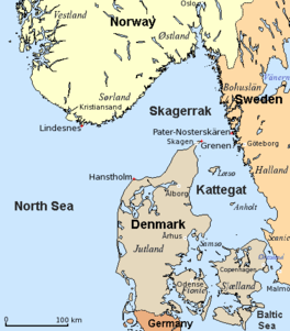
 Map of the Kattegat and Skagerrak | |
| Coordinates | 56°30′N 11°30′E / 56.500°N 11.500°E |
| Etymology | lit. '"cat's gate"' |
| Basin countries | Denmark, Sweden |
| Surface area | 30,000 km2 (12,000 sq mi) |
The Kattegat (Danish: [ˈkʰætəkæt]; Swedish: Kattegatt [ˈkâtːɛˌɡat]) is a 30,000 km2 (12,000 sq mi) sea area bounded by the peninsula of Jutland in the west, the Danish straits islands of Denmark and the Baltic Sea to the south and the Swedish provinces of Bohuslän, Västergötland, Halland and Scania in Sweden in the east. The Baltic Sea drains into the Kattegat through the Danish straits. The sea area is a continuation of the Skagerrak and may be seen as a bay of the North Sea and North Atlantic Ocean, though this is not the case in traditional Scandinavian usage.
The Kattegat is a rather shallow sea and can be dangerous to navigate due to many sandy, stony reefs and the tricky shifting currents. In modern times, artificial seabed channels have been dug, many reefs have been dredged either by sand pumping or boulder clearance,[1] and a well-developed light signaling network has been installed to protect the heavy international traffic on this small sea.
There are several large cities and major ports on the Kattegat, including, in descending size, Gothenburg, Aarhus, Aalborg, Halmstad, Varberg and Frederikshavn.
