Back منطقة كايس Arabic Kayes (bölgə) Azerbaijani کایس اوستانی AZB Кайес (регион) Bulgarian Kayes Region CEB Kayes (region) Danish Region Kayes German Περιφέρεια Καγιές Greek Regiono Kayes Esperanto Región de Kayes Spanish
Kayes Region | |
|---|---|
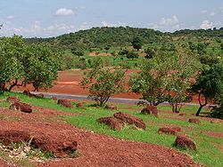
 Sahel forest | |
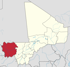
 Location within Mali | |
 Interactive map of Kayes Region in Mali | |
| Coordinates: 14°6′54″N 10°34′7″W / 14.11500°N 10.56861°W | |
| Country | |
| Capital | Kayes |
| Area | |
• Total | 119,743 km2 (46,233 sq mi) |
| Population (2009 census)[1] | |
• Total | 1,996,812 |
| • Density | 17/km2 (43/sq mi) |
| Time zone | UTC±0 (UTC) |
| HDI (2017) | 0.387[2] low |


Kayes Region (Bambara: ߞߊߦߌ ߘߌߣߋߖߊ tr. Kayi Dineja, Arabic: منطقة كايس, romanized: minṭaqa Kāyas) is one of ten first level national subdivisions in Mali called Regions. It is the first administrative area of Mali and covers an area of 120,760 square kilometres or 46,630 square miles. Its capital is the town of Kayes. The province was historically part of the Ghana Empire and the Mali Empire.
- ^ Resultats Provisoires RGPH 2009 (Région de Kayes) (PDF) (in French), République de Mali: Institut National de la Statistique, archived from the original (PDF) on 2012-07-27.
- ^ "Sub-national HDI - Area Database - Global Data Lab". hdi.globaldatalab.org. Retrieved 2018-09-13.