Back کیو، لندن AZB Kew Czech Kew Welsh Kew Danish Kew (London) German Kew Spanish کیو، لندن Persian Kew French Kew Irish क्यू Hindi
| Kew | |
|---|---|
 | |
 Temperate House in Kew Gardens | |
Location within Greater London | |
| Area | 3.30 km2 (1.27 sq mi) |
| Population | 11,436 2011 Census (Kew ward 2011)[1] |
| • Density | 3,465/km2 (8,970/sq mi) |
| OS grid reference | TQ195775 |
| London borough | |
| Ceremonial county | Greater London |
| Region | |
| Country | England |
| Sovereign state | United Kingdom |
| Post town | RICHMOND |
| Postcode district | TW9 |
| Dialling code | 020 |
| Police | Metropolitan |
| Fire | London |
| Ambulance | London |
| UK Parliament | |
| London Assembly | |
Kew (/kjuː/) is a district in the London Borough of Richmond upon Thames.[2] Its population at the 2011 census was 11,436.[1] Kew is the location of the Royal Botanic Gardens ("Kew Gardens"), now a World Heritage Site, which includes Kew Palace. Kew is also the home of important historical documents such as Domesday Book, which is held at The National Archives.
Julius Caesar may have forded the Thames at Kew in 54 BC during the Gallic Wars.[3] Successive Tudor, Stuart and Georgian monarchs maintained links with Kew. During the French Revolution, many refugees established themselves there and it was the home of several artists in the 18th and 19th centuries.
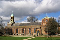
Since 1965 Kew has incorporated the former area of North Sheen[4] which includes St Philip and All Saints, the first barn church consecrated in England.[5] It is now in a combined Church of England parish with St Luke's Church, Kew.
Today, Kew is an expensive residential area because of its prosperous suburban attributes. Among these are sports-and-leisure open spaces, schools, transport links, architecture, restaurants, no high-rise buildings, modest road sizes, trees and gardens. Most of Kew developed in the late 19th century, following the arrival of the District line of the London Underground. Further development took place in the 1920s and 1930s when new houses were built on the market gardens of North Sheen and in the first decade of the 21st century when considerably more river-fronting flats and houses were constructed by the Thames on land formerly owned by Thames Water.
- ^ a b Key Statistics; Quick Statistics: Population Density Office for National Statistics
- ^ "History of Kew, in Richmond upon Thames and Surrey". Map and description, A Vision of Britain through Time. GB Historical GIS / University of Portsmouth. Retrieved 3 July 2023.
- ^ Blomfield 1994, p.3
- ^ Blomfield 1994, p.131
- ^ Blomfield, David. The Story of Kew, second edition, p.36, Leyborne Publications, 1996, ISBN 0 9520515 2 4
