Back ሐቡር ወንዝ Amharic خابور (الفرات) Arabic ܚܒܘܪ ARC خابور ARZ Xabur çayı Azerbaijani خابور چایی AZB Хабур Byelorussian Хабур Bulgarian Khabur Catalan Nahr al Khābūr (suba sa Sirya) CEB
| Khabur | |
|---|---|
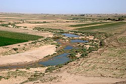
 Khabur south of Al-Hasakah | |
 | |
| Native name | |
| Location | |
| Country | Syria, Turkey |
| City | Ra's al-'Ayn, Al-Hasakah, Busayrah |
| Physical characteristics | |
| Source | Ras al-Ayn |
| • elevation | 350 m (1,150 ft) |
| Mouth | Euphrates |
• coordinates | 35°8′33″N 40°25′51″E / 35.14250°N 40.43083°E |
| Length | 486 km (302 mi) |
| Basin size | 37,081 km2 (14,317 sq mi) |
| Discharge | |
| • average | 45 m3/s (1,600 cu ft/s) |
| • minimum | 2 m3/s (71 cu ft/s) |
| • maximum | 57 m3/s (2,000 cu ft/s) |
| [1][2] | |
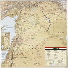
The Khabur River is the largest perennial tributary to the Euphrates in Syria. Although the Khabur originates in Turkey, the karstic springs around Ras al-Ayn are the river's main source of water. Several important wadis join the Khabur north of Al-Hasakah, together creating what is known as the Khabur Triangle, or Upper Khabur area. From north to south, annual rainfall in the Khabur basin decreases from over 400 mm to less than 200 mm. This has made the river a vital water source for agriculture throughout history. The Khabur joins the Euphrates near the town of Busayrah.
- ^ Hole F; Zaitchik, BF (2007). "Policies, plans, practice, and prospects: irrigation in northeastern Syria". Land Degradation & Development. 18 (2): 133–152. doi:10.1002/ldr.772. S2CID 129117310.
- ^ Burdon, DJ; Safadi, C (1963). "Ras-el-Ain: the great karstic spring of Mesopotamia. An hydrogeological study". Journal of Hydrology. 1 (1): 58–95. Bibcode:1963JHyd....1...58B. doi:10.1016/0022-1694(63)90033-7.