Back खटीमा AWA খাতিমা BPY Khatīma CEB Khatima Spanish خاتیما Persian खटीमा Hindi Khatima Italian Khatima Malagasy Khatima Malay खटिमा Nepali
Khatima | |
|---|---|
City | |
 Khatima | |
| Coordinates: 28°55′11.4″N 79°58′11.8″E / 28.919833°N 79.969944°E | |
| Country | |
| State | Uttarakhand |
| District | Udham Singh Nagar |
| Area | |
• Total | 500 km2 (200 sq mi) |
| Population (2011)[1] | |
• Total | 227,226 |
| • Density | 450/km2 (1,200/sq mi) |
| Languages | |
| • Official | Hindi[2] |
| • Additional official | Sanskrit[3][4] |
| • Regional | Kumaoni,Tharu |
| Time zone | UTC+5:30 (IST) |
| PIN | 262308 |
| Telephone code | 05943 |
| Vehicle registration | UK 06 |
| Website | uk |
Preview warning: Page using Template:Infobox settlement with unknown parameter "elevation_km2"
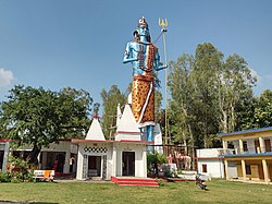
Khatima is a city and a municipal board in Udham Singh Nagar district in the Indian state of Uttarakhand.[1]
Khatima is located at 28°55′N 79°58′E / 28.92°N 79.97°E.[5] It has an average elevation of 299 metres (980 feet).
- ^ a b Cite error: The named reference
Census2011Govwas invoked but never defined (see the help page). - ^ "52nd Report of the Commissioner for Linguistic Minorities in India" (PDF). nclm.nic.in. Ministry of Minority Affairs. p. 18. Archived from the original (PDF) on 25 May 2017. Retrieved 27 May 2019.
- ^ "Sanskrit is second official language in Uttarakhand". Hindustan Times. 19 January 2010. Archived from the original on 27 June 2019. Retrieved 28 January 2020.
- ^ "Sanskrit second official language of Uttarakhand". The Hindu. 21 January 2010. Archived from the original on 3 March 2018. Retrieved 28 January 2020.
- ^ Falling Rain Genomics, Inc - Khatima

