Back Ēadweard Cyning Cofa ANG King Edward Cove German Caleta Vago Spanish King Edward Cove NN 愛德華七世灣 Chinese
| King Edward Cove | |
|---|---|
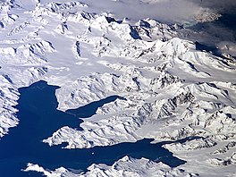
 Central South Georgia: Cumberland Bay; Thatcher Peninsula with King Edward Cove (Grytviken); Allardyce Range with the summit Mount Paget (NASA imagery). | |
| Coordinates | 54°17′S 36°30′W / 54.283°S 36.500°W |
King Edward Cove (Spanish: Caleta Capitán Vago) is a sheltered cove in the west side of Cumberland East Bay, South Georgia. This cove and its surrounding features, frequented by early sealers at South Georgia, was charted by the Swedish Antarctic Expedition, 1901–04, under Otto Nordenskiöld who named it Grytviken. That name, meaning 'Pot Bay,' was subsequently assumed by the whaling station and settlement built in 1904. The cove got its present name in about 1906 for King Edward VII of the United Kingdom.[1]
British Antarctic Survey research station King Edward Point is located on Hope Point, the cove's northernmost headland. Abandoned whaling station Grytviken is located on the cove's western shore.

