Back Koblenz Afrikaans Koblenz RP ALS Coblenza AN كوبلنتس Arabic كوبلنز ARZ Koblenz AST Koblens Azerbaijani کوبلنتس AZB Кобленц Bashkir Koblenz BAR
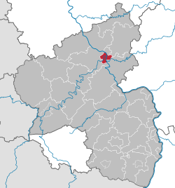
Koblenz | |
|---|---|
 View of the Deutsches Eck and Koblenz Old Town | |
| Coordinates: 50°21′35″N 7°35′52″E / 50.35972°N 7.59778°E | |
| Country | Germany |
| State | Rhineland-Palatinate |
| District | Urban district |
| Government | |
| • Lord mayor (2017–25) | David Langner[1] (Ind.) |
| Area | |
• Total | 105.02 km2 (40.55 sq mi) |
| Elevation | 64.7 m (212.3 ft) |
| Population (2022-12-31)[2] | |
• Total | 115,268 |
| • Density | 1,100/km2 (2,800/sq mi) |
| Time zone | UTC+01:00 (CET) |
| • Summer (DST) | UTC+02:00 (CEST) |
| Postal codes | 56001–56077 |
| Dialling codes | 0261 |
| Vehicle registration | KO |
| Website | koblenz.de |
Koblenz (UK: /koʊˈblɛnts/ koh-BLENTS, US: /ˈkoʊblɛnts/ KOH-blents, German: [ˈkoːblɛnts] ⓘ) is a German city on the banks of the Rhine (Middle Rhine) and the Moselle, a multinational tributary.
Koblenz was established as a Roman military post by Drusus c. 8 BC. Its name originates from the Latin (ad) cōnfluentēs, meaning "(at the) confluence".[3] The actual confluence is today known as the "German Corner", a symbol of the unification of Germany that features an equestrian statue of Emperor William I. The city celebrated its 2,000th anniversary in 1992.
It ranks in population behind Mainz and Ludwigshafen am Rhein to be the third-largest city in Rhineland-Palatinate. Its usual-residents' population is 112,000 (as of 2015[update]). Koblenz lies in a narrow flood plain between high hill ranges, some reaching mountainous height, and is served by an express rail and autobahn network. It is part of the populous Rhineland.
- ^ Wahl der Oberbürgermeister der kreisfreien Städte, Landeswahlleiter Rheinland-Pfalz, accessed 30 July 2021.
- ^ "Bevölkerungsstand 2022, Kreise, Gemeinden, Verbandsgemeinden" (PDF) (in German). Statistisches Landesamt Rheinland-Pfalz. 2023.
- ^ Chisholm, Hugh, ed. (1911). . Encyclopædia Britannica. Vol. 6 (11th ed.). Cambridge University Press. p. 612.


