Back Národní park Kosterhavet Czech Kosterhavets nationalpark Danish Nationalpark Kosterhavet German Parque nacional Kosterhavet Spanish Kosterhavet Parke Nazionala Basque Kosterhavetin kansallispuisto Finnish Parc national de Kosterhavet French Taman Nasional Kosterhavet ID Parco nazionale Kosterhavet Italian კოსტერჰავეტის ეროვნული პარკი Georgian
You can help expand this article with text translated from the corresponding article in French. (December 2011) Click [show] for important translation instructions.
|
| Kosterhavet National Park | |
|---|---|
| Kosterhavets nationalpark | |
 | |
 | |
| Location | Bohuslän, Sweden |
| Nearest city | Strömstad |
| Coordinates | 58°50′N 11°01′E / 58.833°N 11.017°E |
| Area | 388.78 km2 (150.11 sq mi)[1] |
| Established | 2009 |
| Visitors | 90,000 |
| Governing body | Environmental Protection Agency |
| Official website | |
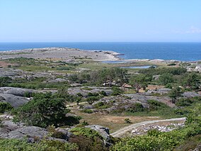
Kosterhavet National Park (Swedish: Kosterhavets nationalpark, literally The Koster Sea National Park) is the first national marine park in Sweden, inaugurated in September 2009.[2] It is part of the Skagerrak sea and is located in Strömstad and Tanum municipalities in Bohuslän, Västra Götaland County, Sweden.[3][4] It consists of the sea and shores around the Koster Islands, excluding everything else on the islands. In the north, it borders the Norwegian marine park of Ytre Hvaler.
Kosterhavet National Park is home to Sweden's largest seal colony.[5]
- ^ "Kosterhavet National Park". Naturvårdsverket. Archived from the original on 2009-09-23. Retrieved 2009-11-05.
- ^ "Kosterhavets webbplats" [Website of the Kosterhavet Marine National Park] (in Swedish). Västra Götaland County Administrative Board. 10 September 2009. Retrieved 10 September 2009.
- ^ "Kosterhavet planeras bli Sveriges första marina nationalpark" (in Swedish). Naturvårdsverket. Archived from the original on 2009-03-30. Retrieved 2009-06-26.
- ^ "Sveriges första marina nationalpark" [Sweden's first marine national park] (in Swedish). Svenska Dagbladet. 19 March 2009. Retrieved 26 June 2009.
- ^ Proctor, James (2014). West Sweden. Bradt Travel Guides. Page 51. ISBN 9781841625591.