Back كيزيلوردا Arabic كيزيلوردا ARZ Qızılorda Azerbaijani Ҡыҙылурҙа Bashkir Кызыларда Byelorussian Кызыларда BE-X-OLD Къзълорда Bulgarian Khizilordà Catalan Кызылорда CE Kyzylorda CEB
Kyzylorda
Қызылорда / Qyzylorda (Kazakh) | |
|---|---|
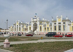
 A train station | |
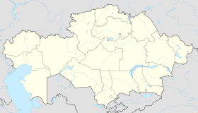
| Coordinates: 44°51′0″N 65°31′0″E / 44.85000°N 65.51667°E | |
| Country | |
| Region | Kyzylorda Region |
| Founded | 1820 |
| City status | 1867 |
| Government | |
| • Akim (mayor) | Nurzhan Akhatov[1] |
| Area | |
• Total | 2,400 km2 (900 sq mi) |
| Elevation | 128 m (420 ft) |
| Population (2019) | |
• Total | 354,800 |
| • Density | 150/km2 (380/sq mi) |
| Time zone | UTC+5 |
| Postal codes | 120001–120018 |
| Area code | +7 7242 |
| Vehicle registration | N or 11 |
| Website | www |
Kyzylorda (Kazakh: Қызылорда / Qyzylorda [qəˌzəɫorˈdɑ] (ⓘ)), formerly known as Kzyl-Orda (Russian: Кзыл-Орда), Ak-Mechet (Ак-Мечеть), Perovsk (Перовск), and Fort-Perovsky (Форт-Перовский), is a city in south-central Kazakhstan, capital of Kyzylorda Region and former capital of the Kazakh ASSR from 1925 to 1927.
The city has a population of 242,462 (2020 Census). It historically developed around the Syr Darya river and was the site of a Kokand fortress. The population of the city with nearby villages is 312,861 (2020 Census).[2]
- ^ "Нового акима назначили в Кызылорде" (in Russian). inform.kz. August 28, 2024.
- ^ "Демографиялық статистика" (in Kazakh). Archived from the original on May 27, 2020. Retrieved October 26, 2020.

