Back للسل أوكس كودريس (كيبك) Arabic L'Isle-aux-Coudres CEB L'Isle-aux-Coudres Spanish L'Isle-aux-Coudres (Quebec) Basque لیل-او-کودر Persian L'Isle-aux-Coudres French L'Isle-aux-Coudres Italian L'Isle-aux-Coudres Swedish
L'Isle-aux-Coudres | |
|---|---|
 | |
 Location within Charlevoix RCM | |
| Coordinates: 47°24′N 70°23′W / 47.400°N 70.383°W | |
| Country | Canada |
| Province | Quebec |
| Region | Capitale-Nationale |
| RCM | Charlevoix |
| Settled | 1728 |
| Constituted | August 23, 2000 |
| Government | |
| • Mayor | Christyan Dufour |
| • Federal riding | Montmorency—Charlevoix —Haute-Côte-Nord |
| • Prov. riding | Charlevoix–Côte-de-Beaupré |
| Area | |
• Total | 100.96 km2 (38.98 sq mi) |
| • Land | 29.46 km2 (11.37 sq mi) |
| Population | |
• Total | 1,116 |
| • Density | 37.9/km2 (98/sq mi) |
| • Pop (2016-21) | |
| • Dwellings | 760 |
| Time zone | UTC−5 (EST) |
| • Summer (DST) | UTC−4 (EDT) |
| Postal code(s) | |
| Area code(s) | 418 and 581 |
| Highways | No major routes |
| Website | www |
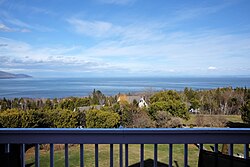
L'Isle-aux-Coudres (French pronunciation: [lil o kudʁ]), is a municipality located on island aux Coudres, in the St. Lawrence River, in Charlevoix Regional County Municipality, Capitale-Nationale region, Quebec, Canada.
Variations of the official name are: La Baleine, L'Île-aux-Coudres, Saint-Bernard-de-l'Île-aux-Coudres and Saint-Louis-de-l'Isle-aux-Coudres. Locally, the following variants are also noted: Île aux Coudriers, Île Elbow, Île aux Marsouins and Île aux Socles.[3][4]
Whereas the modern French spelling for "island" is île, the municipality uses the old French spelling of Isle. Its population centres include La Baleine in the northeast, (Saint-Louis-de-)l'Isle-aux-Coudres in the south, and Saint-Bernard-sur-Mer in the northwest facing Baie-Saint-Paul.
Access to the island are by sea (ferry) and air (airport). The free ferry service connects Saint-Bernard-sur-Mer to Saint-Joseph-de-la-Rive on the north shore of the gulf.[5][6]
It was the setting for the classic 1963 National Film Board of Canada documentary Pour la suite du monde.
- ^ a b "Répertoire des municipalités: Geographic code 16023". www.mamh.gouv.qc.ca (in French). Ministère des Affaires municipales et de l'Habitation. Retrieved 2024-03-08.
- ^ a b "L'Isle-aux-Coudres (Code 2416023) Census Profile". 2021 census. Government of Canada - Statistics Canada. Retrieved 2024-03-08.
- ^ Cite error: The named reference
Island aux Coudreswas invoked but never defined (see the help page). - ^ "L'Isle-aux-Coudres (Municipalité)". Commission de toponymie Quebec (in French). Government of Quebec. 2000-11-09. Retrieved 2023-12-31.
Variations of official name: La Baleine, L'Île-aux-Coudres, Saint-Bernard-de-l'Île-aux-Coudres and Saint-Louis-de-l'Isle-aux-Coudres. Locally, there are also the following variants: Île aux Coudriers, Île Elbow, Île aux Marsouins and Île aux Socles.
- ^ "Île aux Coudres Airport" (in French). 2023-12-31. Retrieved 2023-12-31.
Small airport whit one pist 17/35. pseudo-code OACI de CTA3
- ^ "Ferry L'Isle-aux-Coudres – Saint-Joseph-de-la-Rive". La Société des traversiers du Québec. 2023-12-31. Retrieved 2023-12-31.
Schedule
