Back আম্ফোয়ে লা-উন BPY Amphoe La-un CEB Amphoe La-un German Distretto di La-un Italian ラウン郡 Japanese 라운군 Korean Districtul La-un Romanian อำเภอละอุ่น Thai La-un (huyện) Vietnamese La-un Kūn ZH-MIN-NAN
La-un
ละอุ่น | |
|---|---|
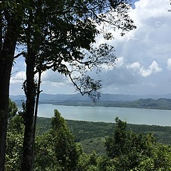
 Kraburi River from Bang Kaeo | |
 District location in Ranong province | |
| Coordinates: 10°6′54″N 98°45′0″E / 10.11500°N 98.75000°E | |
| Country | Thailand |
| Province | Ranong |
| Seat | La-un Tai |
| Area | |
• Total | 748.5 km2 (289.0 sq mi) |
| Population (2023)[1] | |
• Total | 15,240 |
| • Density | 20/km2 (50/sq mi) |
| Time zone | UTC+7 (ICT) |
| ISO 3166 code | TH-8502 |
| Postal code | 85130 |
La-un (Thai: ละอุ่น, pronounced [lā.ʔùn]) is a district (amphoe) of Ranong province, southern Thailand.
- ^ "Official statistics registration systems". Department of Provincial Administration. Retrieved 6 January 2025, year 2023 >village level >ExcelFile >no.8501-8599 >Excel line 85759-85992
{{cite web}}: CS1 maint: postscript (link)