Back Estau La Guaira AN ولاية فارغاس Arabic وارقاس، ونزوئلا AZB Варгас (штат) Byelorussian Варгас (щат) Bulgarian Vargas (stad) Breton Estat de Vargas Catalan Estado Vargas CEB Vargas Danish Vargas (Bundesstaat) German
La Guaira State
Estado La Guaira | |
|---|---|
|
| |
| Motto(s): Igualdad, Libertad, Prosperidad y Seguridad (English: Equality, Liberty, Prosperity and Security) | |
| Anthem: Carmañola Americana | |
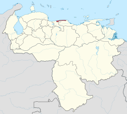
 Location within Venezuela | |
| Coordinates: 10°34′19″N 66°52′48″W / 10.572°N 66.88°W | |
| Country | Venezuela |
| Created | 1998 |
| Capital | La Guaira |
| Government | |
| • Body | Legislative Council |
| • Governor | José Manuel Suárez[1] (2021–) |
| • Assembly delegation | 4 |
| Area | |
• Total | 1,172 km2 (453 sq mi) |
| • Rank | 22nd |
| 0.16% of Venezuela | |
| Population (2011 census est.) | |
• Total | 352,920 |
| • Rank | 21st |
| 1.29% of Venezuela | |
| Time zone | UTC−4 (VET) |
| ISO 3166 code | VE-X |
| Emblematic tree | Uva de Playa (Coccoloba uvífera) |
| HDI (2019) | 0.732[2] high · 5th of 24 |
| Website | www |

La Guaira State (Spanish: Estado La Guaira),[3] known until 2019 as Vargas State (Spanish: Estado Vargas,[3][4] IPA: [esˈtaðo ˈβaɾɣas]), is one of the 23 states of Venezuela.
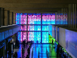
Formerly named after Venezuela's first civilian president, José María Vargas, the state comprises a coastal region in the north of Venezuela, bordering Aragua to the west, Miranda to the east, the Caribbean Sea to the north and the Capital District to the south. It is home to both the country's largest seaport and airport. The state capital and largest city is La Guaira followed by Catia La Mar and Maiquetía. The Litoral Varguense conurbation is the principal urban agglomeration in the state, which is part of the Greater Caracas Area.
In 1999, the geographic center of the state suffered major floods and landslides, known as La Tragedia de Vargas (the Vargas tragedy), causing major losses of life and property, and resulting in forced population movements, including the virtual disappearance of some small towns. Thousands died, and many more fled the area to other states. The state's name was changed on 14 June 2019 to La Guaira.
- ^ "José Manuel Suárez asume la Gobernación de Vargas". Efecto Cocuyo (in Spanish). 2021-05-22. Retrieved 2021-05-23.
- ^ "Sub-national HDI - Area Database - Global Data Lab". hdi.globaldatalab.org. Retrieved 2021-07-31.
- ^ a b "El estado Vargas pasa a llamarse estado La Guaira desde este jueves". El Universal (in Spanish). 2019-06-06. Retrieved 2020-08-30.
- ^ Estado Vargas: aspectos socioeconómicos, función urbana y opciones de desarrollo: Litoral Vargas: corredor urbano y red vial esctructurante (in Spanish). Instituto de Urbanismo, Facultad de Arquitectura y Urbanismo, Universidad Central de Venezuela. 2001.

