Back Lachlan (rehiyon) CEB Lachlan Shire German Comté du Lachlan French Contea di Lachlan Italian Lachlan Shire Council Dutch Lachlan Shire Swedish
| Lachlan Shire New South Wales | |||||||||||||||
|---|---|---|---|---|---|---|---|---|---|---|---|---|---|---|---|
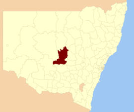
 Location in New South Wales | |||||||||||||||
| Coordinates | 33°03′S 147°09′E / 33.050°S 147.150°E | ||||||||||||||
| Population |
| ||||||||||||||
| • Density | 0.41368/km2 (1.07142/sq mi) | ||||||||||||||
| Area | 14,973 km2 (5,781.1 sq mi) | ||||||||||||||
| Mayor | John Medcalf (Unaligned) | ||||||||||||||
| Council seat | Condobolin[3] | ||||||||||||||
| Region | Central West | ||||||||||||||
| State electorate(s) | Barwon | ||||||||||||||
| Federal division(s) | Parkes | ||||||||||||||
 | |||||||||||||||
| Website | Lachlan Shire | ||||||||||||||
| |||||||||||||||
Lachlan Shire is a local government area in the Central West region of New South Wales, Australia. The Shire is located adjacent to the Lachlan River, the Lachlan Valley Way and the Broken Hill railway line.
The largest town and council seat is Condobolin. The Shire also includes the towns and villages of Albert, Burcher, Fifield, Lake Cargelligo, Tottenham and Tullibigeal.
The mayor of Lachlan Shire Council is Cr. John Medcalf OAM, who is unaligned with any political party.
- ^ Australian Bureau of Statistics (27 June 2017). "Lachlan (A)". 2016 Census QuickStats. Retrieved 8 December 2017.
- ^ "3218.0 – Regional Population Growth, Australia, 2017–18". Australian Bureau of Statistics. 27 March 2019. Retrieved 27 March 2019. Estimated resident population (ERP) at 30 June 2018.
- ^ "Lachlan Shire Council". Division of Local Government. Retrieved 28 November 2006.