Back لهول وسبيتي Arabic لهول وسبيتى ARZ लाहुल अउरी स्पीति जिला Bihari লাহুল এবং স্পিতি জেলা Bengali/Bangla Districte de Lahul i Spiti Catalan Lāhul and Spiti CEB Lahul and Spiti (distrikt) Danish Lahaul und Spiti German Distrito de Lahaul y Spiti Spanish Lahaul and Spiti barrutia Basque
Lahaul and Spiti district | |
|---|---|
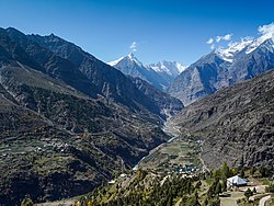
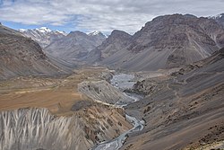
Bhaga valley in Lahaul (top); Spiti valley near Losar (bottom) | |
 Location in Himachal Pradesh | |
| Coordinates (Keylong): 32°30′N 77°36′E / 32.500°N 77.600°E | |
| Country | |
| State | |
| Headquarters | Keylong |
| Government | |
| • Vidhan Sabha constituencies | 01 |
| Area | |
• Total | 13,833 km2 (5,341 sq mi) |
| Population (2011) | |
• Total | 31,564 |
| • Density | 2.3/km2 (5.9/sq mi) |
| • Urban | None |
| Demographics | |
| • Literacy | 86.97% (male), 66.5% (female) |
| • Sex ratio | 916 |
| Time zone | UTC+05:30 (IST) |
| Vehicle registration | HP-41, HP-42, HP-43 |
| Major highways | one (Manali-Leh National Highway) |
| Average annual precipitation | Scanty rainfall |
| Website | https://hplahaulspiti.gov.in |
The Lahaul and Spiti district is a high-altitude district in Himachal Pradesh, north India. This entirely mountainous district consists of two geographically distinct as well as formerly separate political-administrative units, called Lahaul (Tibetan: གར་ཞ་, Wylie: gar zha) and Spiti (Tibetan: སྤི་ཏི་, Wylie: spi ti; or Tibetan: སྤྱི་ཏི, Wylie: spyi ti). Lahaul and Spiti is the largest district by area in Himachal Pradesh, and one of the least populous districts in the whole of India.[1] Kyelang (also spelled as 'Keylong') in Lahaul is the headquarters of the whole district, while Spiti also has a subdivisional headquarters, at Kaza.
- ^ "Top 10 Least Populated Districts Of India". Jagranjosh.com. 17 September 2011. Retrieved 14 January 2025.


