| Lake Abert | |
|---|---|
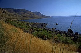
 East shore of Lake Abert | |
| Location | Lake County, Oregon |
| Coordinates | 42°38′30″N 120°13′30″W / 42.64167°N 120.22500°W |
| Type | Endorheic |
| Primary inflows | Chewaucan River |
| Catchment area | 820 sq mi (2,100 km2) |
| Basin countries | United States |
| Max. length | 15 mi (24 km) |
| Max. width | 7 mi (11 km) |
| Surface area | 57 sq mi (150 km2) |
| Max. depth | 11 ft (3.4 m) |
| Surface elevation | 4,259 ft (1,298 m) |
Lake Abert (also known as Abert Lake) is a large, shallow, alkali lake in Lake County, Oregon, United States. It is approximately 15 mi (24 km) long and 7 mi (11 km) wide at its widest point. It is located 3 mi (4.8 km) northeast of the small, unincorporated community of Valley Falls, Oregon. The lake was named in honor of Colonel John James Abert by explorer John C. Fremont during his 1843 expedition into Central Oregon. No fish live in the alkaline waters of the lake; however, its dense population of brine shrimp supports a variety of shorebirds. The lake is an important stop on the bird migration route known as the Pacific flyway.


