This article includes a list of general references, but it lacks sufficient corresponding inline citations. (August 2011) |
| Lake Quannapowitt | |
|---|---|
 | |
| Location | Middlesex County, Massachusetts, U.S. |
| Coordinates | 42°30′54″N 71°04′43″W / 42.51500°N 71.07861°W[1] |
| Type | Reservoir[1] |
| Primary outflows | Saugus River |
| Basin countries | United States |
| Surface area | 0.397 sq mi (1.028 km2) |
| Surface elevation | 79 ft (24 m)[1] |
| Dam | Lake Quannapowitt Dam[2] |
| Settlements | Wakefield |
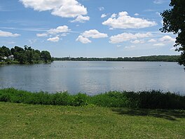
Lake Quannapowitt is a lake in Wakefield, Massachusetts. It is one of two large lakes in Wakefield, the other being the man-made Crystal Lake. The lake is named after Quonopohit,[3] the Naumkeag Native American man who signed a deed to the town that would become Wakefield in 1686.[4] The lake is located off Route 128 in Middlesex County. In 1991, the Friends of Lake Quannapowitt (FOLQ) was founded, which is a non-profit organization intended to protect and bring public awareness to the lake, as well as its nearby public areas. Large amounts of tar were found in the lake in 1999, a by-product of gas manufacturing from coal.[5] The lake is emptied by the Saugus River.
As of 2016[update], two former beaches remain closed to swimming, due to the presence of arsenic, which was introduced into the lake in the early 1960s to handle aquatic weeds.[6] Swimming in the lake is still discouraged as of April 2024[update], especially during algae blooms in the summer months.[7]
The lake has active populations of warm-water species of fish.[4]


The town common of Wakefield abuts the southeastern shore of the lake. Located nearby the lake shore within the common is a gazebo locally called "the Bandstand."
Saugus River | ||||||||||||||||||||||||||||||||||||||||||||||||||||||||||||||||||||||||||||||||||||||||||||||||||||||||||||||||||||||||||||||||||||||||||||||||||||||||||||||||||||||||
|---|---|---|---|---|---|---|---|---|---|---|---|---|---|---|---|---|---|---|---|---|---|---|---|---|---|---|---|---|---|---|---|---|---|---|---|---|---|---|---|---|---|---|---|---|---|---|---|---|---|---|---|---|---|---|---|---|---|---|---|---|---|---|---|---|---|---|---|---|---|---|---|---|---|---|---|---|---|---|---|---|---|---|---|---|---|---|---|---|---|---|---|---|---|---|---|---|---|---|---|---|---|---|---|---|---|---|---|---|---|---|---|---|---|---|---|---|---|---|---|---|---|---|---|---|---|---|---|---|---|---|---|---|---|---|---|---|---|---|---|---|---|---|---|---|---|---|---|---|---|---|---|---|---|---|---|---|---|---|---|---|---|---|---|---|---|---|---|---|
| ||||||||||||||||||||||||||||||||||||||||||||||||||||||||||||||||||||||||||||||||||||||||||||||||||||||||||||||||||||||||||||||||||||||||||||||||||||||||||||||||||||||||
- ^ a b c U.S. Geological Survey Geographic Names Information System: Lake Quannapowitt
- ^ U.S. Geological Survey Geographic Names Information System: Lake Quannapowitt Dam
- ^ Simcox, Alison C. (2011). Lake Quannapowitt. Douglas Heath. Charleston, SC: Arcadia Pub. ISBN 978-0-7385-7389-2. OCLC 679919768.
- ^ a b Perley, Sidney (1912). The Indian land titles of Essex County, Massachusetts. The Library of Congress. Salem, Mass. : Essex Book and Print Club.
- ^ "Cleanup of lake funded - The Boston Globe". archive.boston.com. Retrieved 2017-12-08.
- ^ "Issues Background". northcoastal.net. Archived from the original on 2016-03-04. Retrieved 2017-12-08.
- ^ "FAQ". Friends of Lake Quannapowitt. Retrieved 2024-04-22.
Swimming is not recommended. Rinse pets off immediately if they encounter an algae bloom. Algae blooms in summer (green scum) will cause the lake to be posted by the Board of Health cautioning about swimming and contact with the water. These blooms may produce toxins that could make people and pets sick.


