Back Titicacameer Afrikaans ቲቲካካ ሐይቅ Amharic Laco Titicaca AN بحيرة تيتيكاكا Arabic تيتيكاكا (بحيره) ARZ Llagu Titicaca AST Titiqaqa Aymara Titikaka gölü Azerbaijani Титикака Bashkir Titicacasee BAR
| Lake Titicaca | |
|---|---|
 View of the lake from Isla del Sol | |
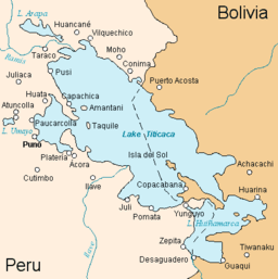
 Map of Lake Titicaca | |
| Coordinates | 15°49′30″S 69°19′30″W / 15.82500°S 69.32500°W |
| Type | Ancient lake |
| Primary inflows | 27 rivers |
| Primary outflows | Desaguadero River |
| Catchment area | 58,000 km2 (22,400 sq mi)[1] |
| Basin countries | Bolivia and Peru |
| Max. length | 190 km (118 mi) |
| Max. width | 80 km (50 mi) |
| Surface area | 8,372 km2 (3,232 sq mi)[1] |
| Average depth | 107 m (351 ft)[1] |
| Max. depth | 281 m (922 ft)[1] |
| Water volume | 896 km3 (215 cu mi)[1] |
| Residence time | 1,343 years[1] |
| Shore length1 | 1,125 km (699 mi)[1] |
| Surface elevation | 3,812 m (12,507 ft)[1] |
| Frozen | never[1] |
| Islands | 42+ (see article) |
| Sections/sub-basins | Wiñaymarka |
| Settlements | Copacabana, Bolivia Puno, Peru |
| References | [1] |
 | |
| Official name | Lago Titicaca |
| Designated | 20 January 1997 |
| Reference no. | 881[2] |
| Official name | Lago Titicaca |
| Designated | 11 September 1998 |
| Reference no. | 959[3] |
| 1 Shore length is not a well-defined measure. | |
Lake Titicaca (/tɪtɪˈkɑːkə/;[4] Spanish: Lago Titicaca [ˈlaɣo titiˈkaka]; Quechua: Titiqaqa Qucha) is a large freshwater lake in the Andes mountains on the border of Bolivia and Peru. It is often called the highest navigable lake in the world. Titicaca is the second largest lake in South America, both in terms of the volume of water and surface area.[5][6][7][a] It has a surface elevation of 3,812 m (12,507 ft).[8][9]
- ^ a b c d e f g h i j Cite error: The named reference
ilecwas invoked but never defined (see the help page). - ^ "Lago Titicaca". Ramsar Sites Information Service. Archived from the original on 13 November 2020. Retrieved 25 April 2018.
- ^ "Lago Titicaca". Ramsar Sites Information Service. Archived from the original on 13 November 2020. Retrieved 25 April 2018.
- ^ "Titicaca". Dictionary.com Unabridged (Online). n.d. Retrieved 10 January 2020.
- ^ Grove, M. J., P. A. Baker, S. L. Cross, C. A. Rigsby and G. O. Seltzer 2003 Application of Strontium Isotopes to Understanding the Hydrology and Paleohydrology of the Altiplano, Bolivia-Peru. Palaeogeography, Palaeoclimatology, Palaeoecology 194:281-297.
- ^ Rigsby, C., P. A. Baker and M. S. Aldenderfer 2003 Fluvial History of the Rio Ilave Valley, Peru, and Its Relationship to Climate and Human History. Palaeogeography, Palaeoclimatology, Palaeoecology 194:165-185
- ^ Questions Unlimited (2003). "Who Wants to Be a Judge at the National Academic Championship?". National Academic Championship. Archived from the original on 6 April 2017. Retrieved 6 December 2016.
- ^ "The World Factbook". cia.gov. Archived from the original on 23 January 2021. Retrieved 27 April 2015.
- ^ "Highest Lake Elevations in the World". About.com Education. Archived from the original on 4 August 2016. Retrieved 27 April 2015.
Cite error: There are <ref group=lower-alpha> tags or {{efn}} templates on this page, but the references will not show without a {{reflist|group=lower-alpha}} template or {{notelist}} template (see the help page).


