Back Laleia (Verwaltungsamt) German Laleia (postu administrativu) TET Laleia Hêng-chèng Tan-ūi ZH-MIN-NAN
You can help expand this article with text translated from the corresponding article in German. (November 2010) Click [show] for important translation instructions.
|
Laleia | |
|---|---|
| |
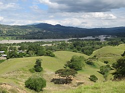
 View of the Laleia River | |
 Official map | |
| Coordinates: 8°32′S 126°10′E / 8.533°S 126.167°E | |
| Country | |
| Municipality | Manatuto |
| Seat | Haturalan |
| Sucos | |
| Area | |
• Total | 226.1 km2 (87.3 sq mi) |
| Population (2015 census) | |
• Total | 3,689 |
| • Density | 16/km2 (42/sq mi) |
| Households (2015 census) | |
| • Total | 719 |
| Time zone | UTC+09:00 (TLT) |
Laleia, officially Laleia Administrative Post (Portuguese: Posto Administrativo de Laleia, Tetum: Postu administrativu Laleia), is an administrative post (and was formerly a subdistrict) in Manatuto municipality, East Timor.[1][2] Its seat or administrative centre is Haturalan.[2]
According to a list prepared by Afonso de Castro, governor of the colony of Portuguese Timor from 1859 to 1863, Laleia was one of 47 kingdoms in that colony at the time.[3]
- ^ "Subdistricts of Timor-Leste". www.statoids.com. 4 May 2010. Retrieved 21 September 2022.
- ^ a b "Diploma Ministerial n.o 24/2014 de 24 de Julho Orgânica dos Postos Administrativos Preâmbulo" [Ministerial Diploma No. 24/2014 of 24 July Organic of Administrative Posts Preamble]. Jornal da República (in Portuguese). Government of East Timor. 24 July 2014. Archived from the original on 4 March 2016. Retrieved 21 September 2022.
- ^ "Timor Loro Sae: Um pouco de história" [Timor Loro Sae: A little history]. A.M.O.C. - Associação dos Militares do Oecussi (in Portuguese). Archived from the original on 13 November 2001. Retrieved 12 January 2025.
