Back لامي دير (مونتانا) Arabic لئیم دیر، مونتانا AZB Lame Deer CEB Meaveʼhoʼeno CHY Lame Deer (Montana) Spanish Lame Deer (Montana) Basque لیم دیر، مونتانا Persian Lame Deer French Lame Deer (Montana) Frisian Lame Deer, Montana Galician
Lame Deer, Montana
Meaveʼhoʼeno | |
|---|---|
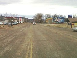
 Looking south on Cheyenne Ave near the center of town. | |
 Location of Lame Deer, Montana | |
| Coordinates: 45°37′23″N 106°40′01″W / 45.62306°N 106.66694°W | |
| Country | United States |
| State | Montana |
| County | Rosebud |
| Area | |
• Total | 55.59 sq mi (143.99 km2) |
| • Land | 55.59 sq mi (143.99 km2) |
| • Water | 0.00 sq mi (0.00 km2) |
| Elevation | 3,865 ft (1,178 m) |
| Population (2020) | |
• Total | 1,897 |
| • Density | 34.12/sq mi (13.17/km2) |
| Time zone | UTC-7 (Mountain (MST)) |
| • Summer (DST) | UTC-6 (MDT) |
| Area code | 406 |
| FIPS code | 30-42250 |
| GNIS feature ID | 2408567[2] |
Lame Deer (Meaveʼhoʼeno in Cheyenne[3]) is a census-designated place (CDP) in Rosebud County, Montana, United States. The community is named after Miniconjou Lakota chief Lame Deer, who was killed by the U.S. Army in 1877 under a flag of truce south of the town.[4] It was the site of a trading post from the late 1870s.[5]
It is the tribal and government agency headquarters of the Northern Cheyenne Indian Reservation. This is the location of the Chief Dull Knife College and the annual Northern Cheyenne Powwow.
- ^ "ArcGIS REST Services Directory". United States Census Bureau. Retrieved September 5, 2022.
- ^ a b U.S. Geological Survey Geographic Names Information System: Lame Deer, Montana
- ^ "Cheyenne Dictionary". Chief Dull Knife College.
- ^ Lame Deer, Seeker of Visions by John Fire, Richard Erdoes, p. xxiii
- ^ "Lame Deer". Montana Place Names Companion. Montana Historical Society. Retrieved April 5, 2021.