Back Municipio de Lancaster (condado de Wells) Spanish Lancaster udalerria, Wells konderria (Indiana) Basque لانکیسٹر ٹاؤنشپ، ویلز کاؤنٹی، انڈیانا Urdu Xã Lancaster, Quận Wells, Indiana Vietnamese 蘭開斯特鎮區 (印地安納州韋爾斯縣) Chinese
Lancaster Township | |
|---|---|
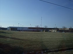
 Norwell High School lies along U.S. Route 224 in northwestern Lancaster Township. | |
 Location in Wells County | |
| Coordinates: 40°47′09″N 85°08′19″W / 40.78583°N 85.13861°W | |
| Country | United States |
| State | Indiana |
| County | Wells |
| Government | |
| • Type | Indiana township |
| Area | |
• Total | 47.98 sq mi (124.3 km2) |
| • Land | 47.59 sq mi (123.3 km2) |
| • Water | 0.39 sq mi (1.0 km2) 0.81% |
| Elevation | 860 ft (262 m) |
| Population | |
• Total | 5,841 |
| • Density | 120/sq mi (47/km2) |
| Time zone | UTC-5 (Eastern (EST)) |
| • Summer (DST) | UTC-4 (EDT) |
| ZIP codes | 46714, 46731, 46733, 46777, 46791 |
| Area code | 260 |
| GNIS feature ID | 453540 |
Lancaster Township is one of nine townships in Wells County, Indiana, United States. As of the 2020 census, its population was 5,841 (up from 5,705 at 2010[3]) and it contained 2,450 housing units.[2]
- ^ "US Board on Geographic Names". United States Geological Survey. October 25, 2007. Retrieved May 9, 2017.
- ^ a b "Census Bureau profile: Jefferson Township, Wells County, Indiana". United States Census Bureau. May 2023. Retrieved April 6, 2024.
- ^ "Population, Housing Units, Area, and Density: 2010 - County -- County Subdivision and Place -- 2010 Census Summary File 1". United States Census. Archived from the original on February 12, 2020. Retrieved May 10, 2013.