Back لاونا ، ویسکانسین AZB Лаона (бахархой лерина меттиг, Висконсин) CE Laona (lungsod) CEB Laona (Wisconsin) German Laona (condado de Forest) Spanish Laona (Wisconsin) Basque لاونا (حوزه سرشماری)، ویسکانسین Persian Laona (hrabstwo Forest) Polish Лаона (сан алу урыны, Висконсин) Tatar Лаона (переписна місцевість, Вісконсин) Ukrainian
Laona, Wisconsin | |
|---|---|
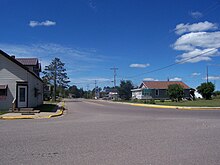
 Looking west in downtown Laona | |
 Location of Laona, Wisconsin | |
| Coordinates: 45°33′26″N 88°41′18″W / 45.55722°N 88.68833°W | |
| Country | United States |
| State | Wisconsin |
| County | Forest |
| Government | |
| • Type | unincorporated |
| Area | |
• Total | 1.948 sq mi (5.05 km2) |
| • Land | 1.948 sq mi (5.05 km2) |
| • Water | 0 sq mi (0 km2) |
| Elevation | 1,572 ft (479 m) |
| Population | |
• Total | 519 |
| • Density | 270/sq mi (100/km2) |
| Time zone | UTC-6 (Central (CST)) |
| • Summer (DST) | UTC-5 (CDT) |
| Area code(s) | 715 & 534 |
| FIPS code | 55-42500[3] |
| GNIS feature ID | 1583528[1] |

Laona is an unincorporated census-designated place in the town of Laona in Forest County, Wisconsin, United States. U.S. Route 8 travels east–west through the community and Wisconsin Highway 32 travels south and west of the community. The community park has a sign stating that the community donated the 1979 Christmas tree at the nation's capitol. As of the 2020 census, its population is 519, down from 583 at the 2010 census.[4]
- ^ a b "US Board on Geographic Names". United States Geological Survey. October 25, 2007. Retrieved January 31, 2008.
- ^ "Census Bureau profile: Laona CDP, Wisconsin". United States Census Bureau. May 2023. Retrieved December 3, 2024.
- ^ "U.S. Census website". United States Census Bureau. Retrieved January 31, 2008.
- ^ "U.S. Census website". U.S. Census Bureau. Retrieved April 13, 2011.