Back লারানজেইরাস BPY Laranjeiras (Rio de Janeiro) BS Laranjeiras Catalan Laranjeiras (Río de Janeiro) Spanish Laranjeiras (Rio de Janeiro) French לרנז'יירס HE Laranjeiras (Rio de Janeiro) Croatian Laranjeiras (Rio de Janeiro) Italian Laranjeiras (Rio de Janeiro) Dutch Laranjeiras (Rio de Janeiro) NB
This article needs additional citations for verification. (July 2014) |
Laranjeiras | |
|---|---|
Neighborhood | |
 | |
| Coordinates: 22°56′09″S 43°11′20″W / 22.93583°S 43.18889°W | |
| Country | |
| State | Rio de Janeiro |
| Municipality | Rio de Janeiro |
| Zone | South Zone |


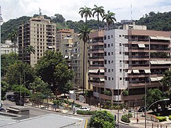
Laranjeiras (Portuguese pronunciation: [laɾɐ̃ˈʒejɾɐʃ], orange trees) is an upper-middle-class neighborhood located in the South Zone of Rio de Janeiro, Brazil. Primarily residential, It is one of the city's oldest neighborhoods, having been founded in the 17th century, with the construction of country houses in the valley located around the Carioca River, which bordered Corcovado Mountain. Because of this, the neighborhood was previously called Vale do Carioca, or Carioca Valley.
While primarily residential, several important governmental, cultural, and sports institutions and schools make this a bustling neighborhood. Well known landmarks in Laranjeiras include the Guanabara Palace (seat of the state government of Rio de Janeiro), the Palácio Laranjeiras (official residence of the state's governor), and the Parque Guinle (Eduardo Guinle Park), as well as the headquarters and Laranjeiras Stadium of Fluminense Football Club, and Rio's branch of the Hebraica Social and Sports Club, and several others.
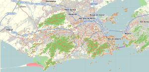
Laranjeiras is adjacent to the Cosme Velho, Catete, Flamengo and Botafogo Neighborhoods.

