Back Larvik (kapital sa munisipyo) CEB Larvik (město) Czech Larvik Estonian Larvik Malay Larvik (plaats) Dutch Larvik NN Larvik Swedish
Larvik
Laurvig (historic) | |
|---|---|
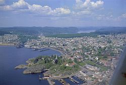
 View of the town harbour | |
| Coordinates: 59°03′12″N 10°02′07″E / 59.05328°N 10.03518°E | |
| Country | Norway |
| Region | Eastern Norway |
| County | Vestfold |
| District | Vestfold |
| Municipality | Larvik Municipality |
| Established as | |
| Kjøpstad | 1671 |
| Area | |
• Total | 15 km2 (6 sq mi) |
| Elevation | 44 m (144 ft) |
| Population (2022)[2] | |
• Total | 26,821 |
| • Density | 1,791/km2 (4,640/sq mi) |
| Demonym(s) | Larvikar Larviker Larviking |
| Time zone | UTC+01:00 (CET) |
| • Summer (DST) | UTC+02:00 (CEST) |
| Post Code | 3256 Larvik |
ⓘ is a town/city[1] in Larvik Municipality in Vestfold county, Norway. The town is the administrative centre of the large municipality which stretches inland for over 50 kilometres (31 mi) from the coast. The town is located near the Skaggerak coast, wedged between the Larviksfjorden to the south, the lake Farris to the north, and the river Lågen along the east side of the town. The town was established in 1671. The town became a self-governing municipality on 1 January 1838 under the formannskapsdistrikt law. The town remained self-governing until 1 January 1988 when it was merged with the neighboring town of Stavern and three neighboring rural municipalities to form a much larger Larvik Municipality.[4]
The 15-square-kilometre (3,700-acre) town has a population (2022) of 26,821 and a population density of 1,791 inhabitants per square kilometre (4,640/sq mi).[2] This means over half of the population of Larvik Municipality lives in the city, the rest live in the much more rural areas of the municipality.
The town originally was built in the Tollerodden area where the Larvik Church is located.[4]
The town is one of the largest ports in Vestfold. It has car ferry connections across the Skaggerak to Hirtshals in Denmark. The Vestfoldbanen railway line runs through the town, stopping at Larvik Station. The European route E18 highway passes through the north side of the town, connecting the capital of Oslo with Southern Norway.[4]
- ^ a b In the Norwegian language, the word by can be translated as "town" or "city".
- ^ a b c Statistisk sentralbyrå (1 January 2022). "Urban settlements. Population and area, by municipality".
- ^ "Larvik, Larvik". yr.no. Retrieved 4 November 2023.
- ^ a b c Thorsnæs, Geir; Lundbo, Sten; Mæhlum, Lars, eds. (15 August 2023). "Larvik". Store norske leksikon (in Norwegian). Kunnskapsforlaget. Retrieved 8 November 2023.

