Back Breedtegraad Afrikaans Geografische Breite ALS Latitut AN عرض (جغرافيا) Arabic Llatitú AST अक्षांश AWA Coğrafi enlik Azerbaijani ائنلم AZB Географик киңлек Bashkir Шырата Byelorussian

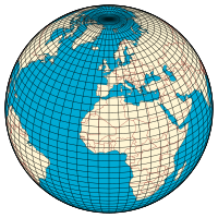
In geography, latitude is a coordinate that specifies the north–south position of a point on the surface of the Earth or another celestial body. Latitude is given as an angle that ranges from −90° at the south pole to 90° at the north pole, with 0° at the Equator. Lines of constant latitude, or parallels, run east–west as circles parallel to the equator. Latitude and longitude are used together as a coordinate pair to specify a location on the surface of the Earth.
On its own, the term "latitude" normally refers to the geodetic latitude as defined below. Briefly, the geodetic latitude of a point is the angle formed between the vector perpendicular (or normal) to the ellipsoidal surface from the point, and the plane of the equator.