Back Leithfield CEB Leithfield (Nouvelle-Zélande) French Leithfield Maori Leithfield Polish Leithfield SIMPLE
Leithfield | |
|---|---|
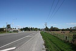
 State Highway 1 at the turn off to Leithfield Beach | |
 | |
| Coordinates: 43°12′S 172°44′E / 43.200°S 172.733°E | |
| Country | New Zealand |
| Region | Canterbury |
| Territorial authority | Hurunui District |
| Ward | South Ward |
| Electorates | |
| Government | |
| • Territorial Authority | Hurunui District Council |
| • Regional council | Environment Canterbury |
| • Mayor of Hurunui | Marie Black |
| • Kaikoura MP | Stuart Smith |
| • Te Tai Tonga MP | Tākuta Ferris |
| Area | |
• Total | 1.58 km2 (0.61 sq mi) |
| Population (June 2024)[2] | |
• Total | 1,040 |
| • Density | 660/km2 (1,700/sq mi) |
Leithfield is a small town in north Canterbury, New Zealand. It is on State Highway 1, 5 kilometres (3.1 mi) south of Amberley and 42 kilometres (26 mi) north of Christchurch and 11.8 kilometres north of Waikuku. The Leithfield area consists of two semi-distinct areas, Leithfield Beach to the east of State Highway 1 and Leithfield Village adjacent to and immediately to the west of State Highway 1. Leithfield sits just south of the South Branch of the Kowai River.
Leithfield's regional importance is behind that of Amberley with its wine industry and the tourist centre of Hanmer Springs. This is due in large part to its proximity to the district centre at Amberley. Despite this proximity, the Leithfield community supports a school, library, summer swimming pool, and many small businesses.
- ^ Cite error: The named reference
Areawas invoked but never defined (see the help page). - ^ "Aotearoa Data Explorer". Statistics New Zealand. Retrieved 26 October 2024.