Back ليروس Arabic Leros Breton Leros Catalan Léros Island CEB Leros (ostrov) Czech Leros Danish Leros German Λέρος Greek Leros Spanish Léros Finnish
Leros
Λέρος | |
|---|---|
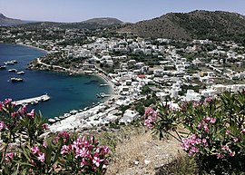
 View of Panteli village in Leros | |
| Coordinates: 37°09′N 26°51′E / 37.150°N 26.850°E | |
| Country | Greece |
| Administrative region | South Aegean |
| Regional unit | Kalymnos |
| Area | |
• Municipality | 74.17 km2 (28.64 sq mi) |
| Highest elevation | 320 m (1,050 ft) |
| Lowest elevation | 0 m (0 ft) |
| Population (2021)[1] | |
• Municipality | 7,992 |
| • Density | 110/km2 (280/sq mi) |
| Time zone | UTC+2 (EET) |
| • Summer (DST) | UTC+3 (EEST) |
| Postal code | 854 00 |
| Area code(s) | 22470 |
| Vehicle registration | ΚΧ, ΡΟ, ΡΚ |
| Website | www.leros.gr |
Leros (Greek: Λέρος), also called Lero (from the Italian language), is a Greek island and municipality in the Dodecanese in the southern Aegean Sea. It lies 317 kilometres (197 miles; 171 nautical miles) from Athens's port of Piraeus, from which it can be reached by a nine-hour ferry ride or by a 45-minute flight from Athens. It is about 32 kilometres (20 miles) from Turkey. Leros is part of the Kalymnos regional unit. It has a population of 7,992 (2021).[1]
- ^ a b "Αποτελέσματα Απογραφής Πληθυσμού - Κατοικιών 2021, Μόνιμος Πληθυσμός κατά οικισμό" [Results of the 2021 Population - Housing Census, Permanent population by settlement] (in Greek). Hellenic Statistical Authority. 29 March 2024.

