Back কেরলের জেলাসমূহের তালিকা Bengali/Bangla Anexo:Distritos del estado de Kerala Spanish Keralan piirikunnat Finnish Liste des districts du Kerala French केरल के जिले Hindi Daftar distrik di Kerala ID ಕೇರಳದ ಜಿಲ್ಲೆಗಳು Kannada കേരളത്തിലെ ജില്ലകളുടെ പട്ടിക Malayalam केरळमधील जिल्हे Marathi Senarai daerah di Kerala Malay
| Districts of Kerala | |
|---|---|
 Districts of Kerala | |
| Category | Districts |
| Location | Kerala |
| Number | 14 districts |
| Populations | Wayanad – 846,637 (lowest); Malappuram – 4,494,998 (highest) |
| Areas | Alappuzha – 1,415 km2 (546 sq mi) (smallest); Idukki – 4,612 km2 (1,781 sq mi) (largest) |
| Government | |
| Subdivisions | |
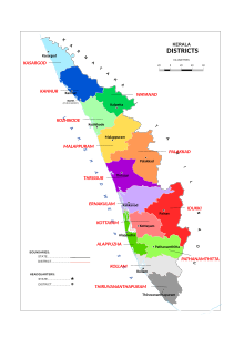
The Indian state of Kerala is divided into 14 districts. Districts are the major administrative units of a state which are further sub-divided into revenue divisions and taluks.[1]
Idukki district is the largest district in Kerala with a total land area of 4,61,223.14 hectares.[2]
When the independent India merged smaller states together, Travancore and Cochin states were integrated to form Travancore-Cochin state on 1 July 1949. However, North Malabar and South Malabar remained under the Madras state. The States Reorganisation Act of 1 November 1956 elevated Kerala to statehood through the unification of Malayalam-speaking territories in the southwestern Malabar Coast of India.
The state comprises three parts – the Northern Kerala districts of Kasaragod, Kannur, Wayanad, Kozhikode, Malappuram; the Central Kerala districts of Palakkad, Thrissur, Ernakulam, Idukki; and the Southern Kerala districts of Kottayam, Alappuzha, Pathanamthitta, Kollam, and Thiruvananthapuram.[3] Such a regional division occurred being part of historical regions of Cochin, North Malabar, South Malabar, and Travancore. The North Malabar region, which is culturally distinct from the rest of Kerala, entirely lies in the districts of Northern Kerala.[4] North Malabar region includes Kasargod, Kannur, Wayanad, and the northern region of Kozhikode district, south Malabar region includes south-central part of Kozhikode district, Malappuram, parts except Chittoor taluk of Palakkad district, Kunnamkulam and Chavakkad region of Thrissur district. The regions of South Malabar and Kingdom of Cochin, both of which share many historical, geographical, and cultural similarities, together constitute the districts of Central Kerala.[4][5] The Travancore region is incorporated in the districts of South Kerala.[6] The Travancore region was again divided into three zones as Northern Travancore (Hill Range) (Idukki District, Kottayam district and eastern portion of Ernakulam district), Central Travancore (Central Range) (Kollam district, Pathanamthitta and Alappuzha district) and Southern Travancore (Southern Range) (Thiruvananthapuram).[7]
The districts in Kerala are often named after the largest town or city in the district. Some of the districts were renamed in 1990 from the anglicised names to their local names. The 14 districts are further divided into 27 revenue divisions, 77 taluks, and 1664 revenue villages.
For local governance, Kerala has 6 Municipal Corporations and 87 Municipalities overseeing urban areas. Additionally, there are 941 Gram Panchayats, 152 Block Panchayats, and 14 District Panchayats responsible for rural governance.
- ^ "Revenue administration (Department of Revenue, Government of Kerala)".
- ^ "Idukki reclaims top spot as Kerala's largest district". English.Mathrubhumi. 11 September 2023. Retrieved 6 July 2024.
- ^ "Central Kerala". Kerala Tourism. Retrieved 12 January 2024.
- ^ a b William Logan (1887). Malabar Manual (Volume-I). Madras Government Press.
- ^ C. Achutha Menon (1911). The Cochin State Manual. Cochin Government Press.
- ^ V. Nagam Aiya (1906). The Travancore State Manual. Travancore Government Press.
- ^ J.B.C. (September 1953). "State of Travancore-Cochin. The Travancore-Cochin Legislative Assembly Manual. (Ernakulam: Government Press. 1952. Pp. xii, 132.)". American Political Science Review. 47 (3): 903–903. doi:10.1017/s0003055400301198. ISSN 0003-0554.